File:Grouse Butt - geograph.org.uk - 113704.jpg
Size of this preview: 450 × 600 pixels. Other resolutions: 180 × 240 pixels | 480 × 640 pixels.
Original file (480 × 640 pixels, file size: 90 KB, MIME type: image/jpeg)
Captions
Captions
Add a one-line explanation of what this file represents
Summary
edit
| Description |
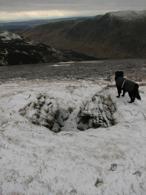
English: Grouse Butt. One of many well made grouse butts on the south side of Auchnafree Hill, now serviced by a rough (unmarked) Landrover track. Looking south. The loops of wire embedded in the top of the wall are presumably for resting guns on. |
| Date | |
| Source | From geograph.org.uk |
| Author | Callum Black |
| Attribution (required by the license) | Callum Black / Grouse Butt / |
| Object location | | View this and other nearby images on: OpenStreetMap |
|---|
_&language=en)
Licensing
edit

|
This image was taken from the Geograph project collection. See this photograph's page on the Geograph website for the photographer's contact details. The copyright on this image is owned by Callum Black and is licensed for reuse under the Creative Commons Attribution-ShareAlike 2.0 license.
|
This file is licensed under the Creative Commons Attribution-Share Alike 2.0 Generic license.
Attribution: Callum Black
- You are free:
- to share – to copy, distribute and transmit the work
- to remix – to adapt the work
- Under the following conditions:
- attribution – You must give appropriate credit, provide a link to the license, and indicate if changes were made. You may do so in any reasonable manner, but not in any way that suggests the licensor endorses you or your use.
- share alike – If you remix, transform, or build upon the material, you must distribute your contributions under the same or compatible license as the original.
File history
Click on a date/time to view the file as it appeared at that time.
| Date/Time | Thumbnail | Dimensions | User | Comment | |
|---|---|---|---|---|---|
| current | 10:07, 31 January 2010 | | 480 × 640 (90 KB) | GeographBot (talk | contribs) | == {{int:filedesc}} == {{Information |description={{en|1=Grouse Butt. One of many well made grouse butts on the south side of Auchnafree Hill, now serviced by a rough (unmarked) Landrover track. Looking south. The loops of wire embedded in the top of th |
You cannot overwrite this file.
File usage on Commons
There are no pages that use this file.