File:Grund Assinghausen.JPG

Size of this preview: 642 × 599 pixels. Other resolutions: 257 × 240 pixels | 514 × 480 pixels | 823 × 768 pixels | 1,097 × 1,024 pixels | 2,195 × 2,048 pixels | 2,932 × 2,736 pixels.
Original file (2,932 × 2,736 pixels, file size: 4.16 MB, MIME type: image/jpeg)
Captions
Captions
Add a one-line explanation of what this file represents
Summary edit
| Description |
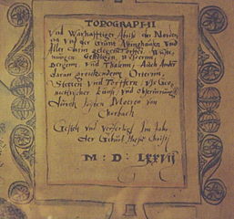
Deutsch: Kartusche der Karte "Topographi und warhafftiger Abriß der Nordena und der Grunt Astinghausen und Aller darin gelegene Torffer, Wüstenungen, Geholtzen, Wessernn, Bergenn und Thalenn, Auch Andern daran grentzendenn Orternn, Stetten und Torffern, uss Geomettrischer kunst und Observirungk durch Joisten Moeren von Chorbach Gestelt und verfertigt Im Jahr der Geburt Jhesu Christi M:D:LXXVII." |
| Date | |
| Source | Foto von einer Reproduktion |
| Author | Joist Moers |
Licensing edit
|
This work is in the public domain in its country of origin and other countries and areas where the copyright term is the author's life plus 100 years or fewer. | |
| This file has been identified as being free of known restrictions under copyright law, including all related and neighboring rights. | |
File history
Click on a date/time to view the file as it appeared at that time.
| Date/Time | Thumbnail | Dimensions | User | Comment | |
|---|---|---|---|---|---|
| current | 13:36, 16 March 2011 | | 2,932 × 2,736 (4.16 MB) | Venetianer (talk | contribs) | {{Information |Description ={{de|1=Kartusche der Karte "Topographi und warhafftiger Abriß der Nordena und der Grunt Astinghausen und Aller darin gelegene Torffer, Wüstenungen, Geholtzen, Wessernn, Bergenn und Thalenn, Auch Andern daran grentzendenn O |
You cannot overwrite this file.
File usage on Commons
The following page uses this file: