File:Guide to common map symbols.png
Size of this preview: 470 × 599 pixels. Other resolutions: 188 × 240 pixels | 506 × 645 pixels.
Original file (506 × 645 pixels, file size: 43 KB, MIME type: image/png)
Captions
Captions
Add a one-line explanation of what this file represents
Summary
edit
| Description |
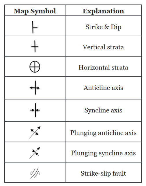
English: A guide to some common symbols found on geologic maps. Includes strike and dip, vertical strata, horizontal strata, anticline axis, syncline axis, plunging anticline axis, plunging syncline axis, and strike-slip fault. |
| Date | |
| Source | https://ung.edu/university-press/books/laboratory-manual-for-introductory-geology.php |
| Author | Randa Harris |

|
This file has been superseded by Guide to common map symbols.svg. It is recommended to use the other file. Please note that deleting superseded images requires consent.
|

|
Licensing
edit
This file is licensed under the Creative Commons Attribution-Share Alike 3.0 Unported license.
- You are free:
- to share – to copy, distribute and transmit the work
- to remix – to adapt the work
- Under the following conditions:
- attribution – You must give appropriate credit, provide a link to the license, and indicate if changes were made. You may do so in any reasonable manner, but not in any way that suggests the licensor endorses you or your use.
- share alike – If you remix, transform, or build upon the material, you must distribute your contributions under the same or compatible license as the original.
File history
Click on a date/time to view the file as it appeared at that time.
| Date/Time | Thumbnail | Dimensions | User | Comment | |
|---|---|---|---|---|---|
| current | 05:55, 18 December 2021 | | 506 × 645 (43 KB) | CrunchyRocks (talk | contribs) | Uploaded a work by Randa Harris from https://ung.edu/university-press/books/laboratory-manual-for-introductory-geology.php with UploadWizard |
You cannot overwrite this file.
File usage on Commons
The following 2 pages use this file: