File:Gulf Coast of the United States (MODIS).jpg

Size of this preview: 800 × 597 pixels. Other resolutions: 320 × 239 pixels | 640 × 477 pixels | 1,024 × 764 pixels | 1,280 × 954 pixels | 2,560 × 1,909 pixels | 3,460 × 2,580 pixels.
Original file (3,460 × 2,580 pixels, file size: 1.05 MB, MIME type: image/jpeg)
Captions
Captions
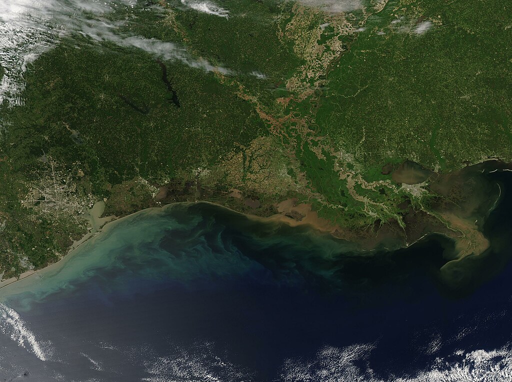
On April 21, 2023, the Moderate Resolution Imaging Spectroradiometer (MODIS) on board NASA’s Aqua satellite captured a springtime view of the Mississippi River Delta and a section of the nearby Gulf Coast.
Summary
edit.jpg&action=edit§ion=1)
| Description |
English: On April 21, 2023, the Moderate Resolution Imaging Spectroradiometer (MODIS) on board NASA’s Aqua satellite captured a springtime view of the Mississippi River Delta and a section of the nearby Gulf Coast. The Delta, located in Louisiana, appears similar to a large bird’s foot protruding into the Gulf of Mexico. To the east, the coasts of Mississippi and Alabama are visible. The coast of Louisiana extends to the west to meet the Texas coastline.
The warm waters of the Gulf of Mexico along with abundant safe harbors has spurred the development of major cities and ports. The largest city visible is Houston, Texas which can be seen near the left (west) edge of the image. Galveston sits along the coast southeast of Houston. Port Arthur, Texas, can be seen as a collect of gray pixels east of Galveston. It is located only 25 miles west of the border of Texas and Louisiana. In Louisiana, gray smudges mark an abundance of cities along the southern section of the Mississippi River. The most famous of these is New Orleans, which can be seen along the southern shore of Lake Pontchartrain. The waters of the Mississippi River, Red River, and Atchafalaya River are stained with mud in several locations as they flow southward. Light-toned land on either side of the Mississippi River is its alluvial floodplain—an area with rich soil and used extensively for agriculture. The Mississippi River drains water and sediment from 31 U.S. states, delivering both to the Gulf of Mexico via the Atchafalaya and Mississippi River Deltas. Reddish-brown sediment marks the location where the Atchafalaya River spills into the Gulf. |
||
| Date | Taken on 22 April 2023 | ||
| Source |
Gulf Coast of the United States (direct link)
|
||
| Author | MODIS Land Rapid Response Team, NASA GSFC |
| This media is a product of the Aqua mission Credit and attribution belongs to the mission team, if not already specified in the "author" row |
Licensing
edit.jpg&action=edit§ion=2)
| This file is in the public domain in the United States because it was solely created by NASA. NASA copyright policy states that "NASA material is not protected by copyright unless noted". (See Template:PD-USGov, NASA copyright policy page or JPL Image Use Policy.) | ||
 |
Warnings:
|
File history
Click on a date/time to view the file as it appeared at that time.
| Date/Time | Thumbnail | Dimensions | User | Comment | |
|---|---|---|---|---|---|
| current | 19:58, 31 July 2023 | | 3,460 × 2,580 (1.05 MB) | OptimusPrimeBot (talk | contribs) | #Spacemedia - Upload of http://modis.gsfc.nasa.gov/gallery/images/image04252023_250m.jpg via Commons:Spacemedia |
You cannot overwrite this file.
File usage on Commons
There are no pages that use this file.
.jpg&oldid=788819647)