File:Gulf Islands map.png

Size of this preview: 690 × 599 pixels. Other resolutions: 276 × 240 pixels | 553 × 480 pixels | 770 × 669 pixels.
Original file (770 × 669 pixels, file size: 288 KB, MIME type: image/png)
Captions
Captions
Add a one-line explanation of what this file represents

|
This locator map image could be re-created using vector graphics as an SVG file. This has several advantages; see Commons:Media for cleanup for more information. If an SVG form of this image is available, please upload it and afterwards replace this template with
{{vector version available|new image name}}.
It is recommended to name the SVG file “Gulf Islands map.svg”—then the template Vector version available (or Vva) does not need the new image name parameter. |
Summary edit
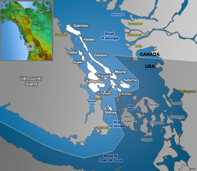
| Description | Map of the Southern Gulf Islands (British Columbia) in the Strait of Georgia, with Canada and the US separated |
| Date | |
| Source | GIS data |
| Author | Qyd |
| Permission (Reusing this file) |
All |
The labels on this map are incorrect. The 'Strait of Georgia' does not extend southward into the San Juan Archipelago, nor does 'Puget Sound' extend northward of the Strait of Juan de Fuca.
Licensing edit
| I, the copyright holder of this work, release this work into the public domain. This applies worldwide. In some countries this may not be legally possible; if so: I grant anyone the right to use this work for any purpose, without any conditions, unless such conditions are required by law. |
File history
Click on a date/time to view the file as it appeared at that time.
| Date/Time | Thumbnail | Dimensions | User | Comment | |
|---|---|---|---|---|---|
| current | 13:39, 22 September 2006 | | 770 × 669 (288 KB) | Qyd (talk | contribs) | move inset, add cities |
| 18:40, 30 August 2006 |  | 770 × 669 (285 KB) | Qyd (talk | contribs) | fix typo | |
| 01:32, 8 August 2006 |  | 770 × 669 (285 KB) | Qyd (talk | contribs) | lesser effects | |
| 01:08, 8 August 2006 |  | 770 × 669 (287 KB) | Qyd (talk | contribs) | {{Information |Description=Map of Gulf Islands (British Columbia) in the Strat of Georgia |Source=GIS data |Date=Aug 2006 |Author=Qyd |Permission=All |other_versions= }} Category:Maps of British Columbia Category:Vancouver Island |
You cannot overwrite this file.
File usage on Commons
The following page uses this file:
File usage on other wikis
The following other wikis use this file:
- Usage on ar.wikipedia.org
- Usage on ast.wikipedia.org
- Usage on bg.wikipedia.org
- Usage on da.wikipedia.org
- Usage on de.wikipedia.org
- Usage on en.wikipedia.org
- Usage on eo.wikipedia.org
- Usage on es.wikipedia.org
- Usage on fa.wikipedia.org
- Usage on fr.wikipedia.org
- Usage on id.wikipedia.org
- Usage on ja.wikipedia.org
- Usage on nl.wikipedia.org
- Usage on pt.wikipedia.org
- Usage on ro.wikipedia.org
- Usage on ru.wikipedia.org
- Usage on sv.wikipedia.org
- Usage on www.wikidata.org
- Usage on zh.wikipedia.org