File:Gulf of Guinea (English).jpg

Size of this preview: 800 × 500 pixels. Other resolutions: 320 × 200 pixels | 640 × 400 pixels | 891 × 557 pixels.
Original file (891 × 557 pixels, file size: 155 KB, MIME type: image/jpeg)
Captions
Captions
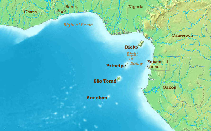
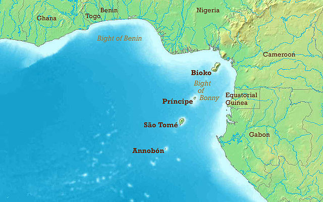
Gulf of Guinea
The Gulf of Guinea with English labels. Map modified from Image:Golf von Guinea.jpg.
- Other_versions available :
- Blank : Image:Gulf_of_Guinea_(blank).jpg
- French : Image:Gulf_of_Guinea-fr.jpg
- German : Image:Golf_von_Guinea.jpg
.jpg)

|
Permission is granted to copy, distribute and/or modify this document under the terms of the GNU Free Documentation License, Version 1.2 or any later version published by the Free Software Foundation; with no Invariant Sections, no Front-Cover Texts, and no Back-Cover Texts. A copy of the license is included in the section entitled GNU Free Documentation License. |
| This file is licensed under the Creative Commons Attribution-Share Alike 3.0 Unported license. | ||
| ||
| This licensing tag was added to this file as part of the GFDL licensing update. |
File history
Click on a date/time to view the file as it appeared at that time.
| Date/Time | Thumbnail | Dimensions | User | Comment | |
|---|---|---|---|---|---|
| current | 20:50, 23 May 2006 | | 891 × 557 (155 KB) | Amcaja (talk | contribs) | The Gulf of Guinea with English labels. Map modified from Image:Golf von Guinea.jpg. {{GFDL}} Category:Guinea Category:Islands Category:Maps of the Atlantic Ocean Category:Maps of Benin Category:Maps of Cameroon [[Category:Maps |
You cannot overwrite this file.
File usage on Commons
The following 5 pages use this file:
File usage on other wikis
The following other wikis use this file:
- Usage on af.wikipedia.org
- Usage on ar.wikipedia.org
- Usage on ast.wikipedia.org
- Usage on azb.wikipedia.org
- Usage on az.wikipedia.org
- Usage on be-tarask.wikipedia.org
- Usage on be.wikipedia.org
- Usage on bg.wikipedia.org
- Usage on bh.wikipedia.org
- Usage on bn.wikipedia.org
- Usage on br.wikipedia.org
- Usage on bs.wikipedia.org
- Usage on ca.wikipedia.org
- Golf de Benín
- Selva de terres baixes de São Tomé, Principe i Annobón
- Llista d'aeroports de São Tomé i Príncipe
- Frontera entre el Gabon i São Tomé i Príncipe
- Frontera entre Nigèria i São Tomé i Príncipe
- Frontera entre Guinea Equatorial i Nigèria
- Resolució 2018 del Consell de Seguretat de les Nacions Unides
- Usage on cs.wikipedia.org
- Usage on cv.wikipedia.org
- Usage on da.wikipedia.org
- Usage on de.wikipedia.org
- Usage on el.wikipedia.org
- Usage on en.wikipedia.org
View more global usage of this file.
.jpg)
.jpg&oldid=679373334)