File:Gwisho culture map.png
No higher resolution available.
Gwisho_culture_map.png (326 × 349 pixels, file size: 13 KB, MIME type: image/png)
Captions
Captions
Add a one-line explanation of what this file represents
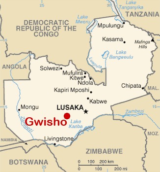
| Description | Location of remains of Gwisho Culture (2800-1700 BCE), near Lonchibar national Park, Kafue river | ||
| Date | |||
| Source | Self work usin the bassis map Image:Zambia-CIA WFB Map.png | ||
| Author | José-Manuel Benito Álvarez —> Locutus Borg | ||
| Permission (Reusing this file) |
|
File history
Click on a date/time to view the file as it appeared at that time.
| Date/Time | Thumbnail | Dimensions | User | Comment | |
|---|---|---|---|---|---|
| current | 20:53, 1 December 2017 | | 326 × 349 (13 KB) | Ras67 (talk | contribs) | cropped and optimized |
| 11:43, 9 September 2006 |  | 330 × 353 (37 KB) | Locutus Borg (talk | contribs) | {{Information |Description= Location of remains of Gwisho Culture (2800-1700 BCE), near Lonchibar national Park, Kafue river |Source= Self work usin the bassis map Image:Zambia-CIA WFB Map.png |Date= september 9, 2006 |Author= José-Manuel Benito Ál |
You cannot overwrite this file.
File usage on Commons
The following 2 pages use this file:
File usage on other wikis
The following other wikis use this file:
- Usage on es.wikipedia.org