File:Hagwilget First Nation location.svg

Size of this PNG preview of this SVG file: 512 × 395 pixels. Other resolutions: 311 × 240 pixels | 622 × 480 pixels | 996 × 768 pixels | 1,280 × 988 pixels | 2,560 × 1,975 pixels.
Original file (SVG file, nominally 512 × 395 pixels, file size: 2.52 MB)
Captions
Captions
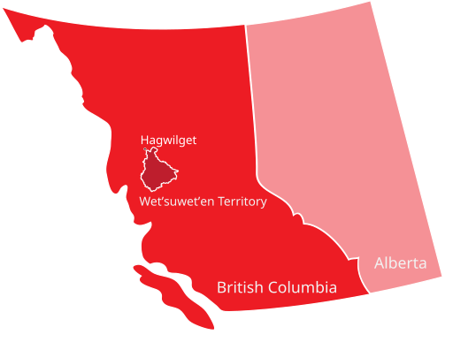
A map showing the location of Hagwilget First Nation
Summary edit
| Description |
English: A map showing the location of Hagwilget First Nation relative to traditional Wetʼsuwetʼen territory within western Canada. |
| Date | |
| Source | Own work, based on below map by DeNovoa2 |
| Author | James Hyett |
| Other versions |
 |
Licensing edit
I, the copyright holder of this work, hereby publish it under the following license:
This file is licensed under the Creative Commons Attribution-Share Alike 4.0 International license.
- You are free:
- to share – to copy, distribute and transmit the work
- to remix – to adapt the work
- Under the following conditions:
- attribution – You must give appropriate credit, provide a link to the license, and indicate if changes were made. You may do so in any reasonable manner, but not in any way that suggests the licensor endorses you or your use.
- share alike – If you remix, transform, or build upon the material, you must distribute your contributions under the same or compatible license as the original.
File history
Click on a date/time to view the file as it appeared at that time.
| Date/Time | Thumbnail | Dimensions | User | Comment | |
|---|---|---|---|---|---|
| current | 21:44, 15 May 2020 | | 512 × 395 (2.52 MB) | James Hyett (talk | contribs) | Uploaded own work with UploadWizard |
You cannot overwrite this file.
File usage on Commons
There are no pages that use this file.
File usage on other wikis
The following other wikis use this file:
- Usage on en.wikipedia.org