File:Halifax DSC 8904 - Interesting history (4309155543).jpg
Original file (2,848 × 4,288 pixels, file size: 8.66 MB, MIME type: image/jpeg)
Captions
Captions
Summary
edit.jpg&action=edit§ion=1)
| Description |
English: PLEASE, no multi invitations in your comments. DO NOT FEEL YOU HAVE TO COMMENT.Thanks.
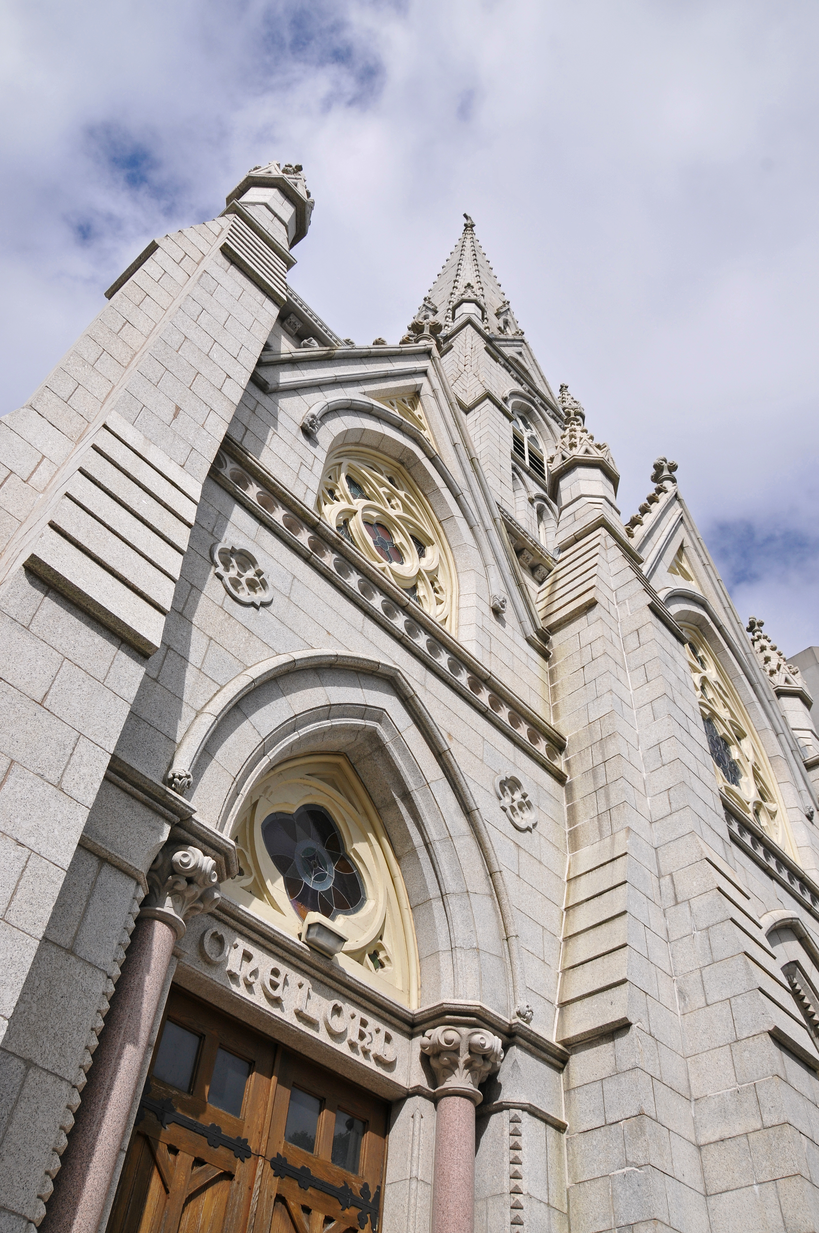
This use to be the location of St. Peter's Catholic Church, now St. Mary's Basilica. This little known church (St. Peter's) was the first Roman Catholic church built in Nova Scotia, in 1783. Up to 1783, there was a public statute stating that no Roman Catholic could hold a public post, nor could the Roman Catholic church own land or erect houses of worship. This law was repealed in 1783. A block of land was subsequently purchased (running up the north side of Spring Garden Road from Barrington Street to Grafton Street) and a small, wooden frame church was built and completed on July 19, 1784. This church was later replaced by St. Mary's Basilica. St. Mary's Basilica was built in Halifax in the area once known as Horseman's Fort, situated close to the south gate of the city's palisade. It was constructed in 1829. It was known at that time to have the tallest polished granite spire in the world. Most of the funds required for purchase of the land and the construction of this church were loans from the Charitable Irish Society and from Indian chiefs in the area. It still has the tallest granite steeple in North America. |
| Date | |
| Source | DSC_8904 - Interesting history |
| Author | Dennis Jarvis from Halifax, Canada |
| Permission (Reusing this file) |
Quote from photographer on numerous files Quoted from user photos
|
| Camera location | | View this and other nearby images on: OpenStreetMap |
|---|
.jpg¶ms=044.644131_N_-063.573052_E_globe:Earth_type:camera_source:Flickr_&language=en)
Licensing
edit.jpg&action=edit§ion=2)
- You are free:
- to share – to copy, distribute and transmit the work
- to remix – to adapt the work
- Under the following conditions:
- attribution – You must give appropriate credit, provide a link to the license, and indicate if changes were made. You may do so in any reasonable manner, but not in any way that suggests the licensor endorses you or your use.
- share alike – If you remix, transform, or build upon the material, you must distribute your contributions under the same or compatible license as the original.
| This image was originally posted to Flickr by archer10 (Dennis) 117M Views at https://flickr.com/photos/22490717@N02/4309155543 (archive). It was reviewed on 3 March 2018 by FlickreviewR 2 and was confirmed to be licensed under the terms of the cc-by-sa-2.0. |
File history
Click on a date/time to view the file as it appeared at that time.
| Date/Time | Thumbnail | Dimensions | User | Comment | |
|---|---|---|---|---|---|
| current | 15:25, 3 March 2018 | | 2,848 × 4,288 (8.66 MB) | Artix Kreiger 2 (talk | contribs) | Transferred from Flickr via Flickr2Commons |
You cannot overwrite this file.
File usage on Commons
The following page uses this file:
- File:DSC 8904 - Interesting history (4309155543).jpg (file redirect)
.jpg&redirect=no)
.jpg&oldid=890910088)