File:Hamp Shire - By H. Moll Geographer - btv1b530564887.jpg

Original file (4,296 × 2,920 pixels, file size: 2.04 MB, MIME type: image/jpeg)
Captions
Captions
Summary edit
| English: Hamp Shire by H. Moll Geographer
( |
|||||||||||||||||||||||||||
|---|---|---|---|---|---|---|---|---|---|---|---|---|---|---|---|---|---|---|---|---|---|---|---|---|---|---|---|
| Author |
|
||||||||||||||||||||||||||
| Title |
English: Hamp Shire by H. Moll Geographer |
||||||||||||||||||||||||||
| Description |
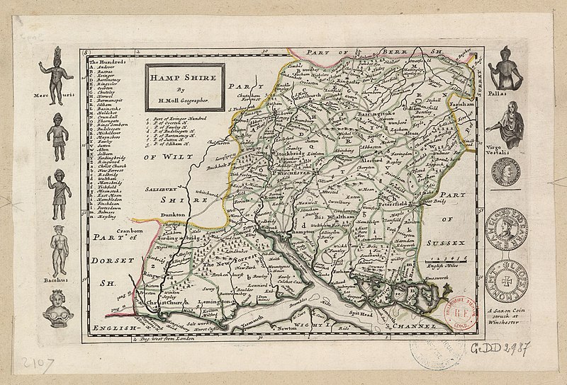
English: Moll's map of Hamp Shire (Hampshire), sold separately and as Map 8 (titled "Hantshire") in his Set of Fifty New and Correct Maps of England and Wales... Illustrations in the margins of a Saxon coin minted at Winchester and of Romano-British statues found in the Southbroom Hoard near Devizes, Wiltshire, in 1714 included here for want of room.
Français : Sujet : Antiquités romaines
Monnaies Divisions politiques et administratives Hampshire, Comté du -- Divisions politiques et administratives Échelle(s) : 6 English Miles [= 2,6 cm] Référence bibliographique : 173 Appartient à l’ensemble documentaire : AnvilEur Appartient à l’ensemble documentaire : MAEDI008 Appartient à l’ensemble documentaire : MAEDIGen0 Couverture : Royaume-Uni – Angleterre – Hampshire Langue : anglais |
||||||||||||||||||||||||||
| Date | 1724 | ||||||||||||||||||||||||||
| Dimensions | Full page: height: 35 cm (13.7 in); width: 23.5 cm (9.2 in) | ||||||||||||||||||||||||||
| Collection |
|
||||||||||||||||||||||||||
| References |
Français : Notice de recueil : http://catalogue.bnf.fr/ark:/12148/cb40577015h
Appartient à : Collection d'Anville ; 02107 Notice du catalogue : http://catalogue.bnf.fr/ark:/12148/cb412471989 |
||||||||||||||||||||||||||
| Source/Photographer |
Français : Bibliothèque nationale de France, département Cartes et plans, GE DD-2987 (2107)
Bibliothèque nationale de France |
||||||||||||||||||||||||||
| Permission (Reusing this file) |
|
||||||||||||||||||||||||||
| Other versions |
|
||||||||||||||||||||||||||


.jpg)


| Annotations | This image is annotated: View the annotations at Commons |
File history
Click on a date/time to view the file as it appeared at that time.
| Date/Time | Thumbnail | Dimensions | User | Comment | |
|---|---|---|---|---|---|
| current | 14:35, 22 July 2022 | | 4,296 × 2,920 (2.04 MB) | Gzen92Bot (talk | contribs) | Gallica btv1b530564887 |
You cannot overwrite this file.
File usage on Commons
The following 12 pages use this file:
- File:Bacchus 2 (Moll).jpg
- File:Denarius from the Southbroom Hoard.jpg
- File:Hamp Shire - By H. Moll Geographer - btv1b530564887.jpg
- File:Mercuris.jpg
- File:Nameless Figure 2.jpg
- File:Nameless Figure 3.jpg
- File:Nameless Figure 4.jpg
- File:Pallas (Moll).jpg
- File:Saxon Coin Struck at Winchester.jpg
- File:Saxon Coin Struck at Winchester (Obverse).jpg
- File:Saxon Coin Struck at Winchester (reverse).jpg
- File:Virgo Vestalis.jpg
.jpg)
.jpg)
.jpg)