File:Hanau-Karte-Altstadt(um 1550).png

Original file (800 × 659 pixels, file size: 24 KB, MIME type: image/png)
Captions
Captions
| Description |
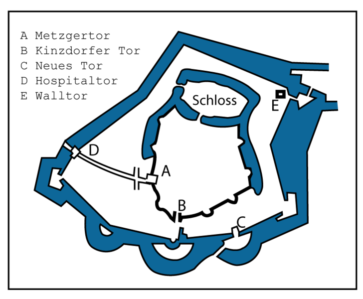
Deutsch: Skizzenkarte der erweiterten Hanauer Altstadt und Befestigung um 1550. English: Sketch map of the extended Hanau old town and fortification around 1550. |
|||||
| Date | C.E.1932 / H.E.11,932 | |||||
| Source |
Deutsch: Bearbeitung einer Abbildung (Abb Nr. 1) aus: Wolf, Gustav: Die Stadt Hanau am Main geographisch betrachtet. In: Schrepfer, Hans (Hg.) Rhein-Mainische Forschungen Heft 6, Frankfurt 1932. English: Processing of an illustration (Fig. No. 1) from: Wolf, Gustav: The city of Hanau am Main viewed geographically. In: Schrepfer, Hans (ed.) Rhein-Mainische Forschungen Issue 6, Frankfurt 1932. |
|||||
| Author | Probably.s. Gustav Wolf. Uploaded & revised by David Liuzzo. | |||||
| Permission (Reusing this file) |
|
|||||
File history
Click on a date/time to view the file as it appeared at that time.
| Date/Time | Thumbnail | Dimensions | User | Comment | |
|---|---|---|---|---|---|
| current | 17:09, 23 December 2009 | | 800 × 659 (24 KB) | David Liuzzo (talk | contribs) | {{Information |Description=Skizzenkarte der erweiterten Hanauer Altstadt und Befestigung um 1550 |Source= Bearbeitung einer Abbildung (Abb Nr. 1) aus: Wolf, Gustav: Die Stadt Hanau am Main geographisch betrachtet. In: Schrepfer, Hans (Hg.) Rhein-Mainische |
You cannot overwrite this file.
File usage on Commons
There are no pages that use this file.
File usage on other wikis
The following other wikis use this file:
- Usage on ca.wikipedia.org
- Usage on de.wikipedia.org
- Usage on en.wikipedia.org
- Usage on es.wikipedia.org
- Usage on hy.wikipedia.org
- Usage on sr.wikipedia.org
.png&oldid=820332330)