File:Hannon map-fi.svg

Size of this PNG preview of this SVG file: 561 × 600 pixels. Other resolutions: 225 × 240 pixels | 449 × 480 pixels | 719 × 768 pixels | 958 × 1,024 pixels | 1,916 × 2,048 pixels | 1,396 × 1,492 pixels.
Original file (SVG file, nominally 1,396 × 1,492 pixels, file size: 754 KB)
Captions
Captions
Add a one-line explanation of what this file represents
| Description |
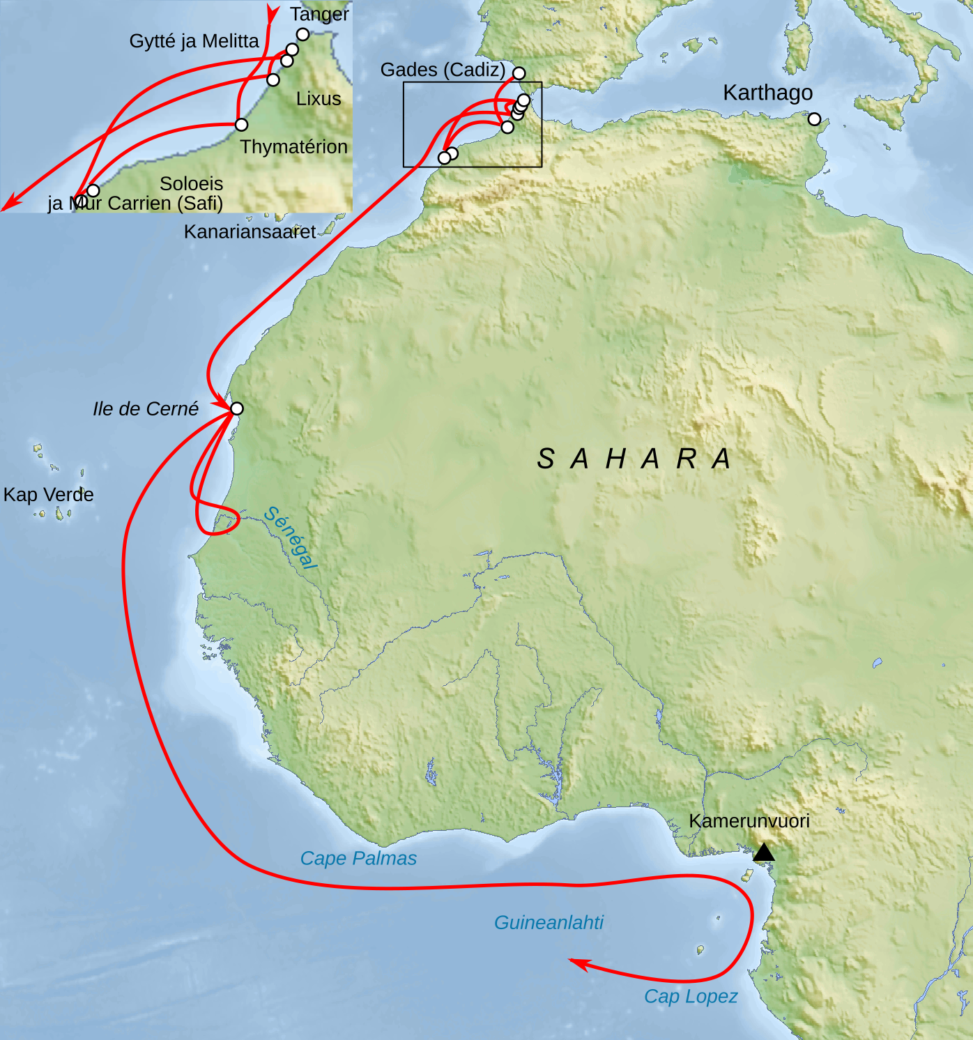
Français : Carte du trajet de Hannon English: Map in French of Hanno the Navigator's exploration Deutsch: Karte in Französisch der Reiseroute von Hanno dem Seefahrer Español: Zona explorada por Hannón el Navegante en su famoso Periplo, en francés |
| Date | (UTC) |
| Source | |
| Author |
|
| This is a retouched picture, which means that it has been digitally altered from its original version. Modifications: Finnish texts. The original can be viewed here: Hannon map-fr.svg:
|
I, the copyright holder of this work, hereby publish it under the following licenses:
This file is licensed under the Creative Commons Attribution-Share Alike 3.0 Unported, 2.5 Generic, 2.0 Generic and 1.0 Generic license.
- You are free:
- to share – to copy, distribute and transmit the work
- to remix – to adapt the work
- Under the following conditions:
- attribution – You must give appropriate credit, provide a link to the license, and indicate if changes were made. You may do so in any reasonable manner, but not in any way that suggests the licensor endorses you or your use.
- share alike – If you remix, transform, or build upon the material, you must distribute your contributions under the same or compatible license as the original.

|
Permission is granted to copy, distribute and/or modify this document under the terms of the GNU Free Documentation License, Version 1.2 or any later version published by the Free Software Foundation; with no Invariant Sections, no Front-Cover Texts, and no Back-Cover Texts. A copy of the license is included in the section entitled GNU Free Documentation License. |
You may select the license of your choice.
Original upload log
edit
This image is a derivative work of the following images:
- File:Hannon_map-fr.svg licensed with Cc-by-sa-3.0,2.5,2.0,1.0, GFDL
- 2009-04-26T18:30:36Z Bourrichon 1396x1492 (772462 Bytes) {{Information |Description={{fr|Carte du trajet de [[:fr:Hannon (navigateur)|]]}}{{en|Map of [[:en:Hanno the Navigator|]]'s exploration}}{{de|Karte der Reiseroute von [[:de:Hanno dem Seefahrer|]]}}{{es|Zona explorada por [[:e
Uploaded with derivativeFX
File history
Click on a date/time to view the file as it appeared at that time.
| Date/Time | Thumbnail | Dimensions | User | Comment | |
|---|---|---|---|---|---|
| current | 12:17, 14 February 2010 | | 1,396 × 1,492 (754 KB) | Cuprum (talk | contribs) | {{Information |Description={{fr|Carte du trajet de Hannon}}{{en|Map in French of Hanno the Navigator's exploration}}{{de|Karte in Franzosich der Reiseroute von [[:de:Hanno dem Seefahrer|Hanno dem Se |
You cannot overwrite this file.
File usage on Commons
The following page uses this file:
File usage on other wikis
The following other wikis use this file:
- Usage on fi.wikipedia.org