File:Harudi Formation map.png

Size of this preview: 666 × 600 pixels. Other resolutions: 266 × 240 pixels | 533 × 480 pixels | 853 × 768 pixels | 1,137 × 1,024 pixels | 1,472 × 1,326 pixels.
Original file (1,472 × 1,326 pixels, file size: 286 KB, MIME type: image/png)
Captions
Captions
Add a one-line explanation of what this file represents
| Description |
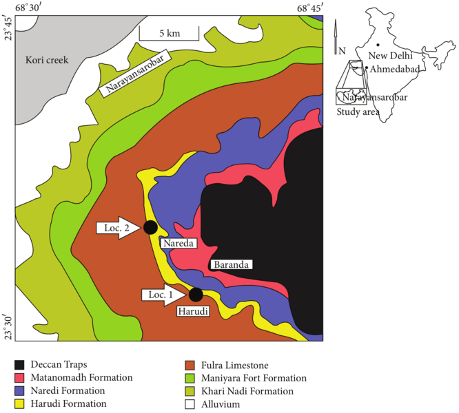
English: Geological map of a part of the Cenozoic exposures of Kutch with fossil localities (modified after Biswas, 1992).[1]
|
| Date | |
| Source | Halder, K., & Sinha, P. (2014). "Some Eocene Cerithioids (Gastropoda, Mollusca) from Kutch, Western India, and Their Bearing on Palaeobiogeography of the Indian Subcontinent". Paleontology Journal, 2014, Article ID 673469, doi:10.1155/2014/673469. Figure 1. Extracted from PDF with resolution 300 dpi. |
| Author | Kalyan Halder & Piyali Sinha |
This file is licensed under the Creative Commons Attribution 3.0 Unported license.
- You are free:
- to share – to copy, distribute and transmit the work
- to remix – to adapt the work
- Under the following conditions:
- attribution – You must give appropriate credit, provide a link to the license, and indicate if changes were made. You may do so in any reasonable manner, but not in any way that suggests the licensor endorses you or your use.
File history
Click on a date/time to view the file as it appeared at that time.
| Date/Time | Thumbnail | Dimensions | User | Comment | |
|---|---|---|---|---|---|
| current | 16:44, 15 November 2017 | | 1,472 × 1,326 (286 KB) | Snek01 (talk | contribs) | {{Information |Description={{en|Geological map of a part of the Cenozoic exposures of Kutch with fossil localities (modified after Biswas, 1992).<ref>Biswas S. K. (1992). “Tertiary stratigraphy of Kutch,” ''Journal of the Palaeontological Society o... |
You cannot overwrite this file.
File usage on Commons
The following page uses this file:
File usage on other wikis
The following other wikis use this file:
- Usage on en.wikipedia.org