File:Hateruma aerial.jpg

Size of this preview: 800 × 450 pixels. Other resolutions: 320 × 180 pixels | 640 × 360 pixels | 1,024 × 576 pixels | 1,600 × 900 pixels.
Original file (1,600 × 900 pixels, file size: 444 KB, MIME type: image/jpeg)
Captions
Captions
Add a one-line explanation of what this file represents
Summary edit
| Description |
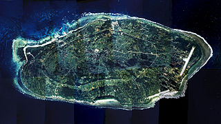
English: Hateruma Island, Taketomi, Okinawa, Japan.
|
| Date | |
| Source | Japan Ministry of Land, Infrastructure and Transport. [1], [2] |
| Author | Retuched by Paipateroma (talk). |
国土交通省の国土画像情報(カラー空中写真)を元に作成。
- 整理番号 COK-77-5
- 撮影年度 昭和52年度
- 地区名 西表島
- 撮影コース C20 / 写真番号 1-9
- 撮影コース C21 / 写真番号 1-9
Licensing edit

|
The copyright holder of this file, the Ministry of Land, Infrastructure, Transport and Tourism of Japan, allows anyone to use it for any purpose, provided that the copyright holder is properly attributed. Redistribution, derivative work, commercial use, and all other use is permitted. |
Attribution:
Copyright © National Land Image Information (Color Aerial Photographs), Ministry of Land, Infrastructure, Transport and Tourism
|
 |
This image is copyrighted by the Ministry of Land, Infrastructure, Transport and Tourism of Japan. For terms of use, see the stipulation to use of National Land Information (in Japanese) and message from MLIT (in Japanese and English). When you display this image on an article, include the following phrase in the description: "Made based on National Land Image Information (Color Aerial Photographs), Ministry of Land, Infrastructure, Transport and Tourism".
|
File history
Click on a date/time to view the file as it appeared at that time.
| Date/Time | Thumbnail | Dimensions | User | Comment | |
|---|---|---|---|---|---|
| current | 18:58, 18 September 2010 | | 1,600 × 900 (444 KB) | Paipateroma (talk | contribs) | {{Information |Description={{en|1=Hateruma Island, Taketomi, Okinawa, Japan.}} {{ja|1=波照間島(沖縄県竹富町)。}} |Source=Japan Ministry of Land, Infrastructure and Transport. [http:// |
You cannot overwrite this file.
File usage on Commons
There are no pages that use this file.
File usage on other wikis
The following other wikis use this file: