File:Haun's Mill marker.jpg

Original file (2,592 × 1,944 pixels, file size: 1.79 MB, MIME type: image/jpeg)
Captions
Captions
Summary
edit
| Description |
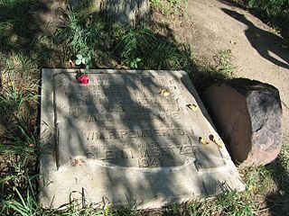
English: 04 Aug 2006 photo of marker at Haun's Mill, Caldwell County, Missouri
22 April 2008 The site of the Haun's Mill well is unknown. This marker designates the approximately 32 acres owned by Jacob Haun in the settlement. In 1887, Josiah Fuller's son visited the site of Haun’s Mill to locate his father's resting-place. With Charles Ross' assistance, Fuller moved a red millstone fragment from the old mill onto the well to commemorate those who died. The stone was partially buried edgeways. In 1888, LDS members Andrew Jenson, Edward Stevenson and Joseph Smith Black visited the site from Utah. They readily located the well by means of the red stone. The red stone apparently remained in place at the well site until 1941 when area resident Glen E. Setzer cast a concrete marker near the entry road. Perhaps unaware of the meaning of the red sandstone standing over the well site, Setzer moved it to the new marker site. The location of the well has been uncertain ever since. The RLDS Church [now Community of Christ] purchased the Haun's Mill property around 1970. In May 2012 it was announced that the The Church of Jesus Christ of Latter-day Saints had acquired the property from the Community of Christ. |
| Date | 16 October 2007 (original upload date) |
| Source | Transferred from en.wikipedia by SreeBot |
| Author | Chinnasue58 at en.wikipedia |
Licensing
edit
- You are free:
- to share – to copy, distribute and transmit the work
- to remix – to adapt the work
- Under the following conditions:
- attribution – You must give appropriate credit, provide a link to the license, and indicate if changes were made. You may do so in any reasonable manner, but not in any way that suggests the licensor endorses you or your use.
- share alike – If you remix, transform, or build upon the material, you must distribute your contributions under the same or compatible license as the original.

|
Permission is granted to copy, distribute and/or modify this document under the terms of the GNU Free Documentation License, Version 1.2 or any later version published by the Free Software Foundation; with no Invariant Sections, no Front-Cover Texts, and no Back-Cover Texts. A copy of the license is included in the section entitled GNU Free Documentation License. |
Original upload log
edit
Upload date | User | Bytes | Dimensions | Comment
- 2007-10-16 17:50 (UTC) | Chinnasue58 | 1879329 (bytes) | 2592×1944 | 04Aug2006 photo of marker at Haun's Mill, Caldwell County, Missouri
File history
Click on a date/time to view the file as it appeared at that time.
| Date/Time | Thumbnail | Dimensions | User | Comment | |
|---|---|---|---|---|---|
| current | 06:38, 11 January 2012 | | 2,592 × 1,944 (1.79 MB) | SreeBot (talk | contribs) | (Original text) : 04Aug2006 photo of marker at Haun's Mill, Caldwell County, Missouri |
You cannot overwrite this file.
File usage on Commons
There are no pages that use this file.
File usage on other wikis
The following other wikis use this file:
- Usage on en.wikipedia.org
- Usage on www.wikidata.org