File:Haute-Normandie region relief location map.jpg

Size of this preview: 465 × 600 pixels. Other resolutions: 186 × 240 pixels | 372 × 480 pixels | 969 × 1,250 pixels.
Original file (969 × 1,250 pixels, file size: 294 KB, MIME type: image/jpeg)
Captions
Captions
Add a one-line explanation of what this file represents
Summary edit
| Camera location | | View this and other nearby images on: OpenStreetMap |
|---|
| Description |
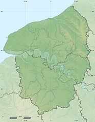
English: Blank physical map of the region of Upper Normandy, France, for geo-location purpose, with distinct boundaries for regions, departments and arrondissements.
Français : Carte physique vierge de la région de Haute-Normandie, France, destinée à la géolocalisation, avec limite distincte des régions, départements et arrondissements. Scales:
Equirectangular projection, WGS84 datum
Geographic limits of the map:
|
||
| Date | |||
| Source |
Own work
|
||
| Author | Eric Gaba (Sting - fr:Sting) | ||
| Permission (Reusing this file) |
|
||
| Other versions |
|

Licensing edit
Eric Gaba, Wikimedia Commons user Sting, the copyright holder of this work, hereby publishes it under the following license:
This file is licensed under the Creative Commons Attribution-Share Alike 3.0 Unported license.
Attribution: Eric Gaba, Wikimedia Commons user Sting
- You are free:
- to share – to copy, distribute and transmit the work
- to remix – to adapt the work
- Under the following conditions:
- attribution – You must give appropriate credit, provide a link to the license, and indicate if changes were made. You may do so in any reasonable manner, but not in any way that suggests the licensor endorses you or your use.
- share alike – If you remix, transform, or build upon the material, you must distribute your contributions under the same or compatible license as the original.
File history
Click on a date/time to view the file as it appeared at that time.
| Date/Time | Thumbnail | Dimensions | User | Comment | |
|---|---|---|---|---|---|
| current | 21:15, 18 July 2010 | | 969 × 1,250 (294 KB) | Sting (talk | contribs) | Color profile |
| 17:03, 10 March 2010 |  | 969 × 1,250 (302 KB) | Sting (talk | contribs) | == {{int:filedesc}} == {{Location|49|21|45|N|00|56|15|E|scale:500000}} <br/> {{Information |Description={{en|Blank physical map of the region of Upper Normandy, France, for geo-location purpose, with distinct boundaries for regions, |
You cannot overwrite this file.
File usage on Commons
The following 4 pages use this file:
File usage on other wikis
The following other wikis use this file:
- Usage on ar.wikipedia.org
- Usage on bg.wikipedia.org
- Usage on ca.wikipedia.org
- Usage on ceb.wikipedia.org
- Usage on ce.wikipedia.org
- Usage on cs.wikipedia.org
- Usage on de.wikipedia.org
- Usage on el.wikipedia.org
- Usage on en.wikipedia.org
- Usage on eo.wikipedia.org
- Usage on es.wikipedia.org
- Usage on fa.wikipedia.org
- Usage on fr.wikipedia.org
- Bataille de Mortemer
- Circuit de Rouen-les-Essarts
- Parc éolien en mer de Fécamp
- Projet:Cartographie/Cartes standards/France
- Parc éolien en mer des Deux-Côtes
- Modèle:Géolocalisation/Haute-Normandie
- Modèle:Géolocdual/Haute-Normandie
- Modèle:Géolocalisation/Haute-Normandie/Documentation
- Wikipédia:Atelier graphique/Cartes/Archives/juin 2010
- Circuit de Dieppe
- Lac de Caniel
- Utilisateur:Wikisoft*/Projet:Cartographie/Géolocalisation/Maintenance/Images des régions françaises
- Projet:Cartographie/Géolocalisation/Maintenance/Images des régions françaises
- Abbaye Saint-Laurent de Beaubec
- Combat de la Rougemare et des Flamants
- Module:Carte/données/haute-normandie
- Usage on gl.wikipedia.org
- Usage on gv.wikipedia.org
- Usage on he.wikipedia.org
- Usage on ja.wikipedia.org
- Usage on kk.wikipedia.org
- Usage on kn.wikipedia.org
- Usage on ko.wikipedia.org
- Usage on la.wikipedia.org
- Usage on lrc.wikipedia.org
- Usage on ms.wikipedia.org
- Usage on pcd.wikipedia.org
- Usage on pl.wikipedia.org
View more global usage of this file.