File:Hawes railway station - geograph.org.uk - 533188.jpg
No higher resolution available.
Hawes_railway_station_-_geograph.org.uk_-_533188.jpg (640 × 478 pixels, file size: 179 KB, MIME type: image/jpeg)
Captions
Captions
Add a one-line explanation of what this file represents
Summary
edit
| Description |
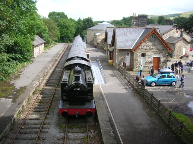
English: Hawes railway station This stretch of track is only about 100 yards, the line is long since dismantled. The line used to run from Northallerton to Garsdale Head where it met the Settle Carlisle line. The station here is now an information centre. |
| Date | |
| Source | From geograph.org.uk |
| Author | DS Pugh |
| Attribution (required by the license) | DS Pugh / Hawes railway station / |
| Camera location | | View this and other nearby images on: OpenStreetMap |
|---|
_heading:112.00&language=en)
| Object location | | View this and other nearby images on: OpenStreetMap |
|---|
_heading:112.00&language=en)
Licensing
edit

|
This image was taken from the Geograph project collection. See this photograph's page on the Geograph website for the photographer's contact details. The copyright on this image is owned by DS Pugh and is licensed for reuse under the Creative Commons Attribution-ShareAlike 2.0 license.
|
This file is licensed under the Creative Commons Attribution-Share Alike 2.0 Generic license.
Attribution: DS Pugh
- You are free:
- to share – to copy, distribute and transmit the work
- to remix – to adapt the work
- Under the following conditions:
- attribution – You must give appropriate credit, provide a link to the license, and indicate if changes were made. You may do so in any reasonable manner, but not in any way that suggests the licensor endorses you or your use.
- share alike – If you remix, transform, or build upon the material, you must distribute your contributions under the same or compatible license as the original.
File history
Click on a date/time to view the file as it appeared at that time.
| Date/Time | Thumbnail | Dimensions | User | Comment | |
|---|---|---|---|---|---|
| current | 20:03, 5 February 2011 | | 640 × 478 (179 KB) | GeographBot (talk | contribs) | == {{int:filedesc}} == {{Information |description={{en|1=Hawes railway station This stretch of track is only about 100 yards, the line is long since dismantled. The line used to run from Northallerton to Garsdale Head where it met the Settle Carlisle line |
You cannot overwrite this file.
File usage on Commons
There are no pages that use this file.
File usage on other wikis
The following other wikis use this file:
- Usage on en.wikipedia.org