File:Helsinki subdivisions-sv.svg

Size of this PNG preview of this SVG file: 762 × 600 pixels. Other resolutions: 305 × 240 pixels | 610 × 480 pixels | 976 × 768 pixels | 1,280 × 1,007 pixels | 2,560 × 2,015 pixels | 1,230 × 968 pixels.
Original file (SVG file, nominally 1,230 × 968 pixels, file size: 313 KB)
Captions
Captions
Add a one-line explanation of what this file represents
Summary edit
| Description |
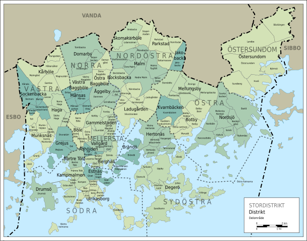
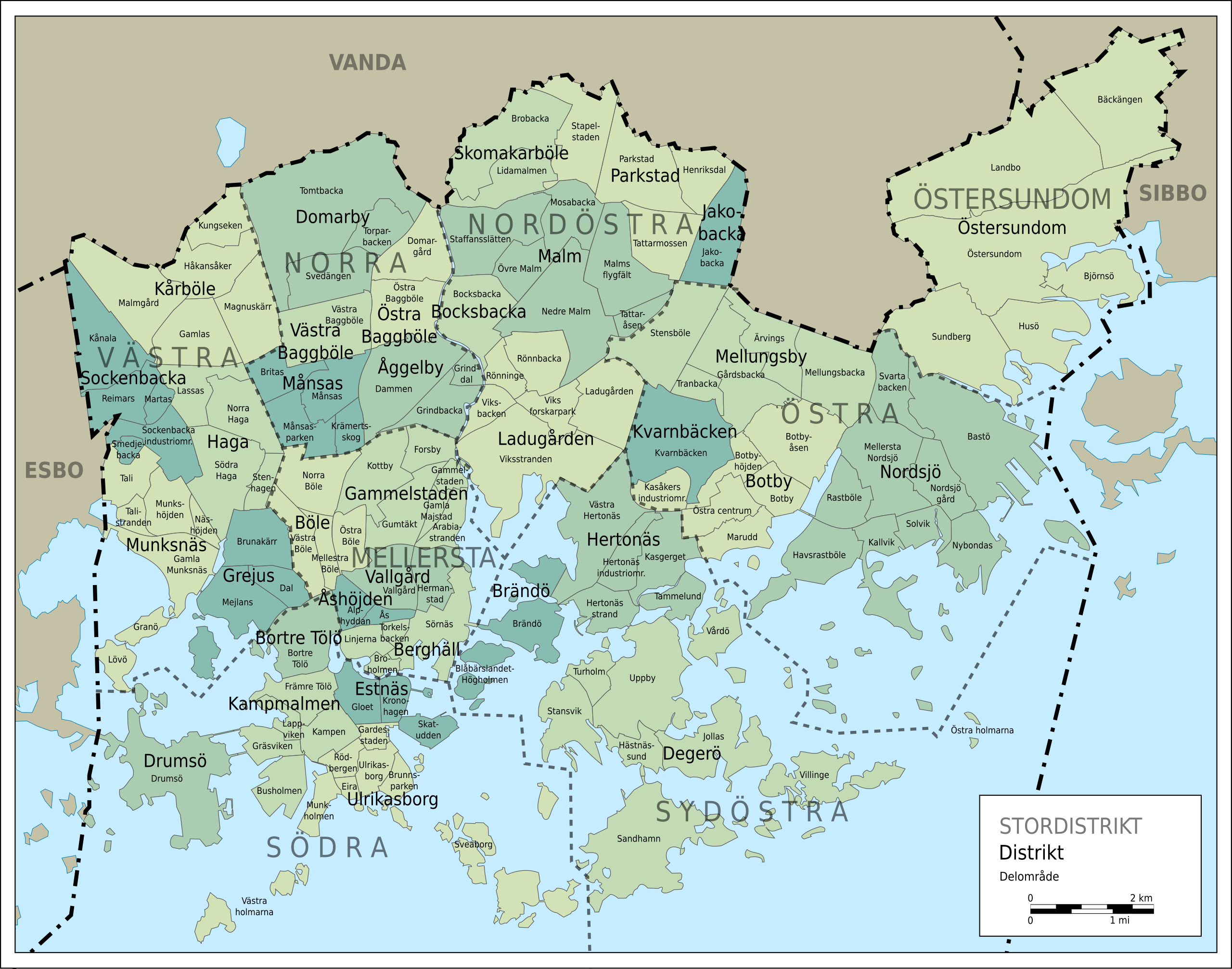
Svenska: Helsingfors administrativa indelning: stordistrikt, distrikt och delområden. |
| Date | |
| Source | Self-made in Inkscape. Sub-district boundaries from Ningyou's map Image:Helsinki districts.svg. |
| Author | Oona Räisänen (Mysid) |
| Other versions | Image:Helsinki subdivisions-fi.svg |
Licensing edit
I, the copyright holder of this work, hereby publish it under the following licenses:
This file is licensed under the Creative Commons Attribution-Share Alike 3.0 Unported license.
- You are free:
- to share – to copy, distribute and transmit the work
- to remix – to adapt the work
- Under the following conditions:
- attribution – You must give appropriate credit, provide a link to the license, and indicate if changes were made. You may do so in any reasonable manner, but not in any way that suggests the licensor endorses you or your use.
- share alike – If you remix, transform, or build upon the material, you must distribute your contributions under the same or compatible license as the original.

|
Permission is granted to copy, distribute and/or modify this document under the terms of the GNU Free Documentation License, Version 1.2 or any later version published by the Free Software Foundation; with no Invariant Sections, no Front-Cover Texts, and no Back-Cover Texts. A copy of the license is included in the section entitled GNU Free Documentation License. |
You may select the license of your choice.
File history
Click on a date/time to view the file as it appeared at that time.
| Date/Time | Thumbnail | Dimensions | User | Comment | |
|---|---|---|---|---|---|
| current | 08:01, 19 August 2010 | | 1,230 × 968 (313 KB) | Stadscykel (talk | contribs) | Södra holmarna -> Östra holmarna |
| 07:58, 19 August 2010 |  | 1,230 × 968 (313 KB) | Stadscykel (talk | contribs) | Ulrikaborg -> Ulrikasborg | |
| 10:10, 24 July 2010 |  | 1,230 × 968 (324 KB) | Mysid (talk | contribs) | Moving the Sveaborg text on top of the main islands | |
| 21:06, 22 July 2010 |  | 1,230 × 968 (324 KB) | Mysid (talk | contribs) | == Summary == {{Information |Description={{sv|1=Helsingfors administrativa indelning: stordistrikt, distrikt och delområden.}} {{fi|1=}} |Source=Self-made in Inkscape. Neighborhood boundaries from Ningyou's map Image:Helsinki districts.svg. |Author= |
You cannot overwrite this file.
File usage on Commons
The following page uses this file:
File usage on other wikis
The following other wikis use this file:
- Usage on sv.wikipedia.org