File:HickoryFlatsBoundary.png

Size of this preview: 800 × 540 pixels. Other resolutions: 320 × 216 pixels | 640 × 432 pixels | 1,024 × 691 pixels | 1,280 × 864 pixels | 2,033 × 1,372 pixels.
Original file (2,033 × 1,372 pixels, file size: 4.52 MB, MIME type: image/png)
Captions
Captions
Add a one-line explanation of what this file represents
Summary edit
| Description |
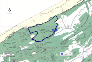
English: The file shows the boundary of Hickory Flats in the Jefferson National Forest |
| Date | |
| Source |
the file was created by drawing a boundary on a scanned image of the Forest Service map "Jefferson National Forest (North Half), Virginia, 1983, Recreation Guide R8-RG 167, reprinted June 1997”. A jpg file of the scanned image is  |
| Author | US Forest Service |
this file had been deleted because source information had not been properly identified
Licensing edit
This image is in the public domain in the United States because it only contains materials that originally came from the United States Geological Survey, an agency of the United States Department of the Interior. For more information, see the official USGS copyright policy.
|
File history
Click on a date/time to view the file as it appeared at that time.
| Date/Time | Thumbnail | Dimensions | User | Comment | |
|---|---|---|---|---|---|
| current | 08:49, 10 November 2017 | | 2,033 × 1,372 (4.52 MB) | WilderAddict (talk | contribs) | User created page with UploadWizard |
You cannot overwrite this file.
File usage on Commons
The following page uses this file:
- File:HickoryFlats.png (file redirect)
File usage on other wikis
The following other wikis use this file:
- Usage on en.wikipedia.org