File:High Arctic tundra map.svg

Size of this PNG preview of this SVG file: 515 × 599 pixels. Other resolutions: 206 × 240 pixels | 412 × 480 pixels | 660 × 768 pixels | 880 × 1,024 pixels | 1,760 × 2,048 pixels | 1,712 × 1,992 pixels.
Original file (SVG file, nominally 1,712 × 1,992 pixels, file size: 364 KB)
Captions
Captions
Add a one-line explanation of what this file represents
Summary
edit
| Description |
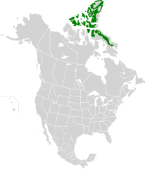
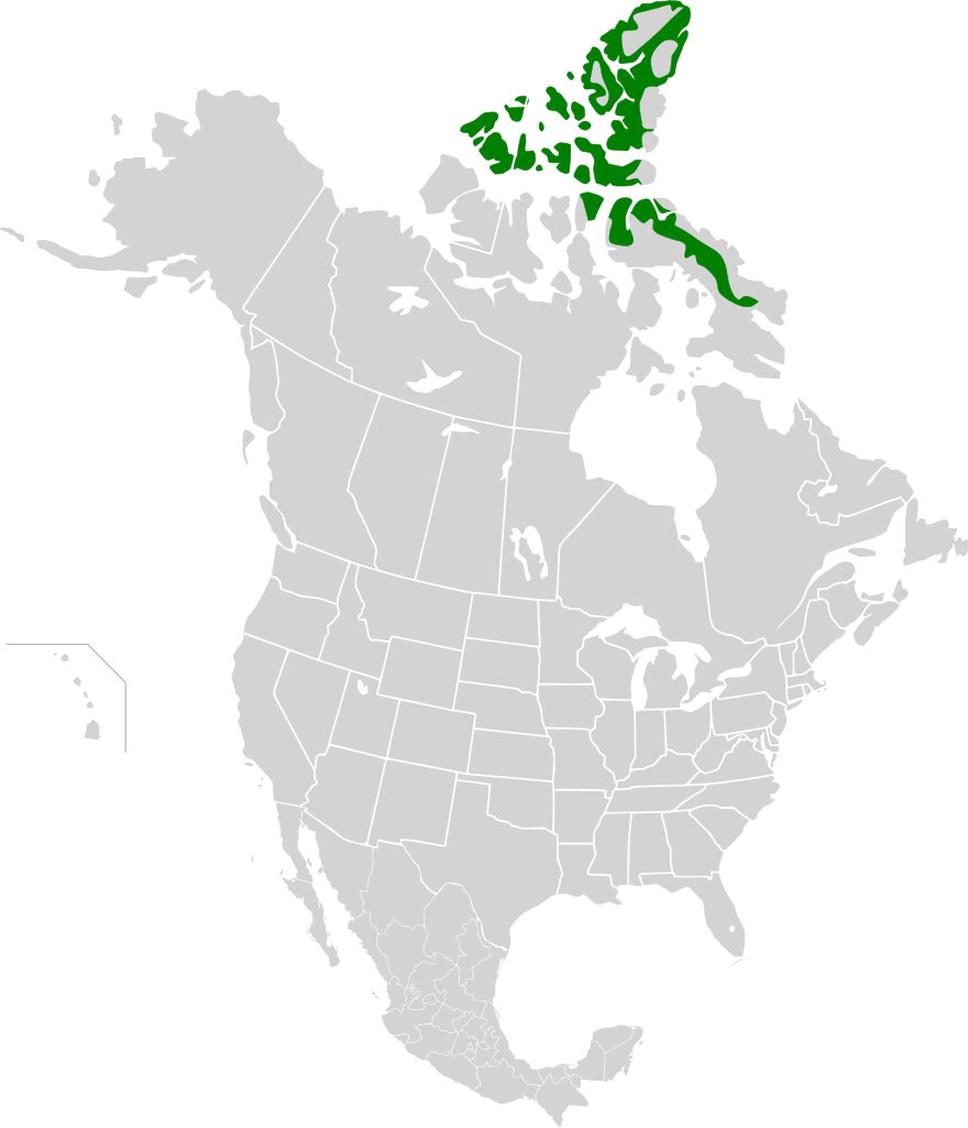
English: Approximate area of the High Arctic tundra ecoregion
Français : Aire approximative de l'écorégion de la Toundra des hautes-terres de Davis |
| Date | |
| Source |
|
| Author | Cephas |
Licensing
edit
I, the copyright holder of this work, hereby publish it under the following licenses:

|
Permission is granted to copy, distribute and/or modify this document under the terms of the GNU Free Documentation License, Version 1.2 or any later version published by the Free Software Foundation; with no Invariant Sections, no Front-Cover Texts, and no Back-Cover Texts. A copy of the license is included in the section entitled GNU Free Documentation License. |
This file is licensed under the Creative Commons Attribution-Share Alike 3.0 Unported, 2.5 Generic, 2.0 Generic and 1.0 Generic license.
- You are free:
- to share – to copy, distribute and transmit the work
- to remix – to adapt the work
- Under the following conditions:
- attribution – You must give appropriate credit, provide a link to the license, and indicate if changes were made. You may do so in any reasonable manner, but not in any way that suggests the licensor endorses you or your use.
- share alike – If you remix, transform, or build upon the material, you must distribute your contributions under the same or compatible license as the original.
You may select the license of your choice.
File history
Click on a date/time to view the file as it appeared at that time.
| Date/Time | Thumbnail | Dimensions | User | Comment | |
|---|---|---|---|---|---|
| current | 21:33, 19 September 2010 | | 1,712 × 1,992 (364 KB) | Cephas (talk | contribs) | This ecoregion not on Banks island |
| 20:36, 18 September 2010 |  | 1,712 × 1,992 (364 KB) | Cephas (talk | contribs) | {{Information |Description={{en|1=Approximate area of the High Arctic tundra ecoregion}} {{fr|1=Aire approximative de l'écorégion de la Toundra des hautes-terres de Davis}} |Source=*[[:File:North America second |
You cannot overwrite this file.
File usage on Commons
The following page uses this file:
File usage on other wikis
The following other wikis use this file:
- Usage on en.wikipedia.org
- Usage on fr.wikipedia.org
- Usage on ru.wikipedia.org
- Usage on uk.wikipedia.org
- Usage on www.wikidata.org