File:High Speed Railroad Map of Europe 2016.svg

Size of this PNG preview of this SVG file: 800 × 600 pixels. Other resolutions: 320 × 240 pixels | 640 × 480 pixels | 1,024 × 768 pixels | 1,280 × 960 pixels | 2,560 × 1,920 pixels.
Original file (SVG file, nominally 800 × 600 pixels, file size: 749 KB)
Captions
Captions
Add a one-line explanation of what this file represents
Summary edit
| Description |
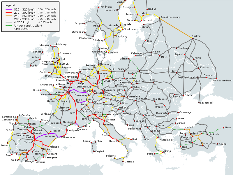
English (en): High-speed railway network in Europe in 20161
310-320km/h (192-198mph) 270-300km/h (167-186mph) 240-260km/h (149-162mph) 200-230km/h (124-142mph) Under construction/Upgrading (dashed lines) Less than 200km/h (124mph)
1 The map depicts the actual operational high-speed instead of the designed one which may be higher.
Deutsch (de): Europäisches Hochgeschwindigkeitsbahnnetz 20161
310-320 km/h 270-300 km/h 240-260 km/h 200-230 km/h Im Bau/Ausbau (Strichlinien) Weniger als 200 km/h
1 Die Karte zeigt die Betriebshöchstgeschwindigkeit anstatt der für die Linie ausgelegten Höchstgeschwindigkeit, welche höher sein kann.
español (es): Red de ferrocarriles de alta velocidad europea en 20161
310-320 km/h 270-300 km/h 240-260 km/h 200-230 km/h En construcción (líneas rayadas) Menos de 200 km/h
1 El mapa sólo incluye la máxima velocidad comercial de las vías.
suomi (fi): Euroopan suurnopeusrataverkosto vuonna 20161
310-320 km/h 270-300 km/h 240-260 km/h 200-230 km/h Rakenteilla (katkoviivalliset) Alle 200 km/h
1 Kartassa on esitetty toteutuvien operointinopeuksien sijasta teoreettiset ratojen huippunopeudet, jotka saattavat olla todellisia liikennöintinopeuksia korkeampia.
français (fr): Réseau ferré européen à grande vitesse 20161
310-320 km/h 270-300 km/h 240-260 km/h 200-230 km/h En construction (pointillés) Moins de 200 km/h
1 Seules les vitesses pratiquées sur les lignes sont prises en compte, pas les vitesses supportées ou théoriques.
Türkçe (tr): 2016'te Avrupa'da yüksek hızlı demiryolu ağı1
310-320km/s 270-300km/s 240-260km/s 200-230km/s İnşa halinde (çizgili yerler) 200km/s'den az
1 Harita teorik hız yerine fiili işletme hızını yansıtmaktadır. Teorik hız fiili hızdan daha yüksek olabilir.
Ελληνικά (el): Το σιδηροδρομικό δίκτυο υπερταχείας στην Ευρώπη το 2016
310-320 km/h 270-300 km/h 240-260 km/h 200-230 km/h υπό κατασκευή (διακεκομμένη γραμμή) κάτω από 200 km/h
italiano (it): Rete ferroviaria ad alta velocità europea 20161
310-320 km/h 270-300 km/h 240-260 km/h 200-230 km/h In construzione (linee tratteggiate) Meno di 200 km/h
1 La mappa considera la velocità operativa massima, non la velocità massima nominale.
Nederlands (nl): Europese netwerk van hogsenelheidslijnen in 2016
310-320 km/h 270-300 km/h 240-260 km/h 200-230 km/h In aanbouw (linee tratteggiate) Minder dan 200 km/h
čeština (cs): Vysokorychlostní železniční síť v Evropě v roce 20161
310-320km/h 270-300km/h 240-260km/h 200-230km/h Ve výstavbě (přerušovaná čára) Méně než 200km/h
1 Mapa zobrazuje aktuální provozní rychlost místo projektované, která může být vyšší.
|
| Date | |
| Source |
This file was derived from: High Speed Railroad Map Europe 2011.svg |
| Author |
Original PNG : User:Bernese media, User:BIL 2011 SVG version: User:Akwa and others (see source file) |
| Other versions |
|


Source edit
English: Derived from File:High Speed Railroad Map of Europe.svg, last 2016 revision.
Licensing edit
This file is licensed under the Creative Commons Attribution-Share Alike 3.0 Unported license.
- You are free:
- to share – to copy, distribute and transmit the work
- to remix – to adapt the work
- Under the following conditions:
- attribution – You must give appropriate credit, provide a link to the license, and indicate if changes were made. You may do so in any reasonable manner, but not in any way that suggests the licensor endorses you or your use.
- share alike – If you remix, transform, or build upon the material, you must distribute your contributions under the same or compatible license as the original.
File history
Click on a date/time to view the file as it appeared at that time.
| Date/Time | Thumbnail | Dimensions | User | Comment | |
|---|---|---|---|---|---|
| current | 22:55, 1 March 2017 | | 800 × 600 (749 KB) | Jklamo (talk | contribs) | {{Information |Description= {{legend-table|lang=en|title=High-speed railway network in Europe in 2016<sup>1</sup> |#ae00ff|310-320km/h (192-198mph) |#ff0000|270-300km/h (167-186mph) |#e39d1a|240-260km/h (149-162mph) |#ffee00|200-230km/h (124-142mph) |#... |
You cannot overwrite this file.
File usage on Commons
The following 3 pages use this file:
File usage on other wikis
The following other wikis use this file:
- Usage on www.wikidata.org