File:Highways Agency Automated Weather Station near Cold Ashton. - panoramio.jpg

Size of this preview: 450 × 600 pixels. Other resolutions: 180 × 240 pixels | 360 × 480 pixels | 576 × 768 pixels | 768 × 1,024 pixels | 2,112 × 2,816 pixels.
Original file (2,112 × 2,816 pixels, file size: 1.31 MB, MIME type: image/jpeg)
Captions
Captions
Add a one-line explanation of what this file represents
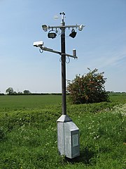
| Description | Highways Agency Automated Weather Station near Cold Ashton. | ||
| Date | 13 May 2008 (original upload date) | ||
| Source | https://web.archive.org/web/20161012021158/http://www.panoramio.com/photo/10184855 | ||
| Author | Bob&Anne Powell | ||
| Permission (Reusing this file) |
This file is licensed under the Creative Commons Attribution-Share Alike 3.0 Unported license. Attribution: Bob&Anne Powell
|
| Camera location | | View this and other nearby images on: OpenStreetMap |
|---|
File history
Click on a date/time to view the file as it appeared at that time.
| Date/Time | Thumbnail | Dimensions | User | Comment | |
|---|---|---|---|---|---|
| current | 12:17, 22 March 2016 | | 2,112 × 2,816 (1.31 MB) | Panoramio upload bot (talk | contribs) | {{Information |description=Highways Agency Automated Weather Station near Cold Ashton. |date={{Original upload date|2008-05-13}} |source=http://www.panoramio.com/photo/10184855 |author=[http://www.panoramio.com/user/777952?with_photo_id=10184855 Bob&am... |
You cannot overwrite this file.
File usage on Commons
There are no pages that use this file.