File:Highways through the great oil, gas, mining, industrial & agricultural areas of the United States LOC 89692265.tif
Size of this JPG preview of this TIF file: 583 × 599 pixels. Other resolutions: 233 × 240 pixels | 467 × 480 pixels | 747 × 768 pixels | 996 × 1,024 pixels | 1,992 × 2,048 pixels | 6,686 × 6,875 pixels.
Original file (6,686 × 6,875 pixels, file size: 131.51 MB, MIME type: image/tiff)
Captions
Captions
Add a one-line explanation of what this file represents
Summary edit
| Description |
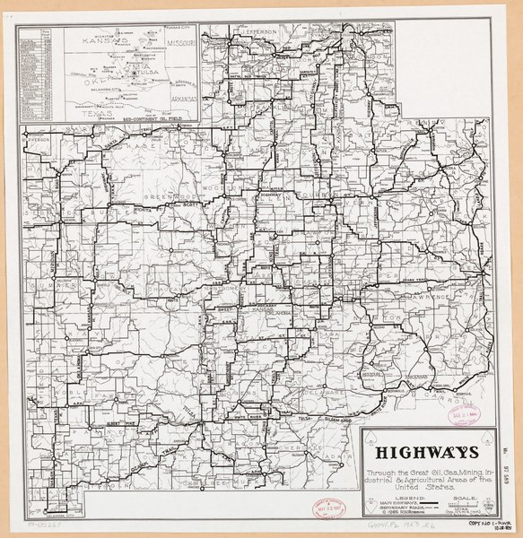
English: VAu 97-589 U.S. Copyright Office "Circa 1923." Covers southeastern Kansas, northeastern Oklahoma, southwestern Missouri, and Benton and Carroll counties, Arkansas. Includes list of "Sea elevations" and inset of Mid-Continent Oil Field. Available also through the Library of Congress Web site as a raster image. LC copy annotated with black felt pen: Copy no. 1-RWR, 10-18-85. |
||
| Title | Highways through the great oil, gas, mining, industrial & agricultural areas of the United States | ||
| Shelf ID | G4041.P2 1923 .R6 MLC | ||
| Date | |||
| Source | https://www.loc.gov/item/89692265/ | ||
| Author | Robson, F. W. (Floyd William) | ||
| Permission (Reusing this file) |
|
||
| Other versions |
|
||
| Location | Oklahoma. · Oklahoma · Kansas · Kansas. · United States · Missouri · Missouri. | ||
| Part of | American Memory · General Maps · Catalog · Geography And Map Division | ||
| Subject | Oklahoma · Kansas · United States · Maps · Missouri · Roads |


Licensing edit
|
This is a faithful photographic reproduction of a two-dimensional, public domain work of art. The work of art itself is in the public domain for the following reason:
The official position taken by the Wikimedia Foundation is that "faithful reproductions of two-dimensional public domain works of art are public domain".
This photographic reproduction is therefore also considered to be in the public domain in the United States. In other jurisdictions, re-use of this content may be restricted; see Reuse of PD-Art photographs for details. | ||||
File history
Click on a date/time to view the file as it appeared at that time.
| Date/Time | Thumbnail | Dimensions | User | Comment | |
|---|---|---|---|---|---|
| current | 11:59, 11 January 2020 |  | 6,686 × 6,875 (131.51 MB) | Fæ (talk | contribs) | LOC Maps https://www.loc.gov/item/89692265/ #33079 |
You cannot overwrite this file.
File usage on Commons
The following page uses this file: