File:Himpact.png

Size of this preview: 800 × 400 pixels. Other resolutions: 320 × 160 pixels | 640 × 320 pixels | 1,024 × 512 pixels | 1,280 × 640 pixels | 3,600 × 1,800 pixels.
Original file (3,600 × 1,800 pixels, file size: 454 KB, MIME type: image/png)
Captions
Captions
Add a one-line explanation of what this file represents
Summary
edit
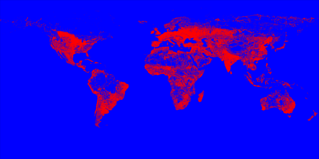
| Description |
English: Areas of human impacts on the Biosphere (roads, railways and settlement density) |
| Date | between 2001 and 2002 |
| Source | http://globio.info |
| Author | T. Hengl |
File description: http://spatial-analyst.net/worldmaps/himpact.rdc
Licensing
edit
This file is licensed under the Creative Commons Attribution-Share Alike 3.0 Unported license.
- You are free:
- to share – to copy, distribute and transmit the work
- to remix – to adapt the work
- Under the following conditions:
- attribution – You must give appropriate credit, provide a link to the license, and indicate if changes were made. You may do so in any reasonable manner, but not in any way that suggests the licensor endorses you or your use.
- share alike – If you remix, transform, or build upon the material, you must distribute your contributions under the same or compatible license as the original.
File history
Click on a date/time to view the file as it appeared at that time.
| Date/Time | Thumbnail | Dimensions | User | Comment | |
|---|---|---|---|---|---|
| current | 09:25, 1 April 2010 | | 3,600 × 1,800 (454 KB) | Hengl (talk | contribs) | Reduced size 50% |
| 23:15, 31 March 2010 |  | 7,200 × 3,600 (755 KB) | Hengl (talk | contribs) | {{Information |Description={{en|1=Areas of human impacts on the Biosphere (roads, railways and settlement density)}} |Source=http://globio.info |Author=United Nations Environment Programme |Date=2001-2002 |Permission= |other_versions= }} File description: |
You cannot overwrite this file.
File usage on Commons
The following page uses this file: