File:Historic American Buildings Survey. Copy of plan of Fort McHenry, November 9, 1803, authorship unknown. National Archives, Records of the War Department, Cartographic Section, HABS MD,4-BALT,5-14.tif

Size of this JPG preview of this TIF file: 800 × 574 pixels. Other resolutions: 320 × 230 pixels | 640 × 459 pixels | 1,024 × 734 pixels | 1,280 × 918 pixels | 2,560 × 1,836 pixels | 5,000 × 3,586 pixels.
Original file (5,000 × 3,586 pixels, file size: 17.1 MB, MIME type: image/tiff)
Captions
Captions
Add a one-line explanation of what this file represents
Summary edit
| Title |
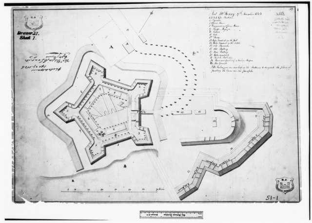
Historic American Buildings Survey. Copy of plan of Fort McHenry, November 9, 1803, authorship unknown. National Archives, Records of the War Department, Cartographic Section, Record Group 77, drawer 51, sheet 1. - Fort McHenry National Monument and Historic Shrine, East Fort Avenue at Whetstone Point, Baltimore, Independent City, MD |
|||
| Description |
Fort Whetstone; Key, Francis Scott; Armistead, George; Pickersgill, Mary; Foncin, Jean; U.S. Navy, photographer; Peterson, Charles E., photographer; Boucher, Jack E., photographer; Nelson, Lee H., historian; Carroll, Orville W., delineator; Nelson, Harold A., delineator; Nelson, Trevor, delineator; Barr, Benjamin F., delineator; Wrenn, George L., delineator |
|||
| Depicted place | Maryland; Independent City; Baltimore | |||
| Date | 1803 | |||
| Dimensions | 5 x 7 in. | |||
| Current location |
Library of Congress Prints and Photographs Division Washington, D.C. 20540 USA http://hdl.loc.gov/loc.pnp/pp.print |
|||
| Accession number |
HABS MD,4-BALT,5-14 |
|||
| Credit line |
|
|||
| Notes |
|
|||
| Source | https://www.loc.gov/pictures/item/md0905.photos.086758p | |||
| Permission (Reusing this file) |
|

File history
Click on a date/time to view the file as it appeared at that time.
| Date/Time | Thumbnail | Dimensions | User | Comment | |
|---|---|---|---|---|---|
| current | 12:45, 22 July 2014 |  | 5,000 × 3,586 (17.1 MB) | Fæ (talk | contribs) | GWToolset: Creating mediafile for Fæ. HABS 21 July 2014 (1601:1800) |
You cannot overwrite this file.
File usage on Commons
The following 2 pages use this file: