File:Historic heritage sites of Telangana with GPS coordinates.jpg

Original file (1,796 × 2,370 pixels, file size: 903 KB, MIME type: image/jpeg)
Captions
Captions
Summary edit
| Description |
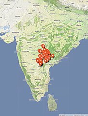
English: Telangana is a southern state of India, marked by its Deccan (Dakhin) terrain. The state is home to monuments that span over 2000 years of Indian history related to ancient and medieval era Buddhism, Hinduism and Jainism. Additionally, the state hosts relatively more recent monuments related to Islam with Persian influences.
The pre-15th century Telangana monuments are predominantly Hindu from the 5th century to the 14th century. These represent a fusion of arts and architectures from the north, south, east and west India, as well as architectural styles and Kakatiya dynasty innovations unique to Telangana. Of these, the monuments near the Srisailam dam reservoir in the south Telangana such as those in Alampur attract much pilgrimage and reverence by regional Hindus, as well as been a subject of comparative studies by scholars. Many of these sites are in ruins and were mutilated after the 13th century. In addition to the ruins of Hindu monuments, ruins of major important Jain and Buddhist sites and artwork are also found in Telangana. A list of major pre-14th century sites pinned in this map are listed below. The GPS coordinates are based on actual field surveys and visits since 2016. This list is not exhaustive. Bhadradri Sita Ramachandraswamy Devasthanam, Bhadrachalam 17°40′00″N 80°52′57″E / 17.66677°N 80.882624°E Kondalamma Temple, Garla 17°30′36″N 80°10′13″E / 17.509868°N 80.170291°E Nelakondapalli Buddha Stupa, Nelakondapally 17°06′43″N 80°04′06″E / 17.111864°N 80.068390°E Devuni Gutta, Kothur 18°06′54″N 80°02′14″E / 18.115116°N 80.037132°E Muktesvara Shiva temple, Kusumanchi 17°14′01″N 79°57′01″E / 17.233608°N 79.950309°E Shivalayam, Kusumanchi 17°13′57″N 79°56′59″E / 17.23252°N 79.949669°E Shiva temple 1, Ramappa lake 18°14′56″N 79°56′38″E / 18.24882°N 79.944015°E Ramappa Temple, Palempet 18°15′33″N 79°56′36″E / 18.25927°N 79.943317°E Shiva temples 2, Ramappa Lake 18°15′08″N 79°56′20″E / 18.25226°N 79.938998°E Abbapuram Shivalayam, Jakaram 18°10′12″N 79°52′42″E / 18.16988°N 79.878346°E Ganapeshwaralayam Kota Gullu, Ghanpur 18°19′03″N 79°52′39″E / 18.317462°N 79.877465°E Kakatiya Ganapuram temple, Ghanpur 18°18′41″N 79°52′34″E / 18.31148°N 79.876217°E Shivalayam Kotagullu, Katakshapur 18°05′56″N 79°48′26″E / 18.09899°N 79.807357°E Venugopala Swamy Temple, Sirikonda 17°11′40″N 79°46′41″E / 17.19451°N 79.778015°E Kakatiya temple, Khammampalli 18°32′19″N 79°42′16″E / 18.53858°N 79.704460°E Shivalayam, Khammampalli 18°32′19″N 79°42′11″E / 18.53856°N 79.703043°E Gowthameeshwara Temple, Manthani 18°40′13″N 79°40′50″E / 18.67036°N 79.680440°E Kakatiya Mantrakuta temple, Manthani 18°40′13″N 79°40′49″E / 18.67021°N 79.680338°E Meenakshi Agasteswara Swamy Temple, Wadapalli 16°41′34″N 79°40′15″E / 16.69285°N 79.670821°E Lakshmi Narasimha Swamy Temple, Wadapalli 16°41′39″N 79°39′59″E / 16.69428°N 79.666409°E Ekaveera Yellamma temple, Mogilicherla 18°00′49″N 79°39′22″E / 18.01368°N 79.656229°E Nagulapahad Temple, Nagulapahad 16°59′46″N 79°36′54″E / 16.99618°N 79.614869°E Shivalayam, Nagulapahad 16°59′52″N 79°36′53″E / 16.99782°N 79.614615°E Fort Park and Kush Mahal, Warangal 17°57′21″N 79°36′55″E / 17.95591°N 79.615327°E Parvathi Mahadeva Nameshwara Temple, Pillalamarri 17°10′09″N 79°35′04″E / 17.169110°N 79.584571°E Trikuteshwara Aalayam, Pillalamarri 17°10′09″N 79°35′04″E / 17.16928°N 79.584568°E Yerakeshwara Swami Temple, Pillalamarri 17°10′11″N 79°34′55″E / 17.16978°N 79.582054°E Thousand Pillar Temple, Hanamkonda 18°00′13″N 79°34′29″E / 18.00371°N 79.574745°E Inavolu Mallanna Temple, Inavolu 17°51′59″N 79°32′45″E / 17.86633°N 79.545969°E Five Hundred Pillar Temple, Kondaparthy 17°55′21″N 79°32′20″E / 17.92241°N 79.538770°E Kondaparthy Temple, Kondaparthy 17°55′18″N 79°32′16″E / 17.92158°N 79.537886°E Shivalayam, Phanigiri 17°25′19″N 79°28′23″E / 17.42196°N 79.473158°E Phanigiri Buddhist Site, Hill top Buddhist site 17°25′37″N 79°28′21″E / 17.42695°N 79.472444°E Kakatiya Temple, Gujjulapalli 18°11′51″N 79°20′11″E / 18.197485°N 79.336508°E Chaya Someshwara Temple, Panagal 17°04′39″N 79°17′43″E / 17.07745°N 79.295239°E Pachchala Someshwara Temple, Panagal 17°04′47″N 79°17′17″E / 17.07972°N 79.288169°E Dhulikatta Buddhist Stupa Site, Southwest of Vadkapur 18°36′35″N 79°16′18″E / 18.60964°N 79.271718°E Nagarjunakonda Archaeological Museum, Nagarjunakonda 16°31′26″N 79°14′42″E / 16.52388°N 79.245108°E Trikutalayam, Nidigonda 17°43′55″N 79°14′03″E / 17.73189°N 79.234052°E Trikutalayam, Naganur 18°30′02″N 79°08′56″E / 18.50065°N 79.148954°E Venkateshwara Swamy Temple, Nagunur 18°30′08″N 79°08′30″E / 18.50231°N 79.141711°E Garuda Pillars, Naganoor 18°30′24″N 79°08′30″E / 18.50678°N 79.141549°E Shiva Temple, Nagunur 18°30′23″N 79°08′28″E / 18.50629°N 79.141017°E Kakatiya Shivalaya, Nagunur 18°30′18″N 79°08′27″E / 18.505038°N 79.140823°E Lakshmi Narasimha Swami Devasthanam, Dharmapuri 18°57′01″N 79°05′51″E / 18.95019°N 79.097443°E Chikati Gudi, Kothapalli H 18°29′39″N 79°05′46″E / 18.49405°N 79.096160°E Renukarcharya Swamy temple and museum, Kolanupaka 17°41′56″N 79°01′56″E / 17.69882°N 79.032312°E Laxmi Narasimha Swamy temple, Bejanki 18°14′55″N 79°00′50″E / 18.248743°N 79.013855°E Mallanna Swamy Temple, Komuravelle 17°55′47″N 78°53′46″E / 17.929801°N 78.896221°E Raja Rajeshwara Swamy temple, Vemulawada 18°28′02″N 78°52′15″E / 18.46729°N 78.870914°E Kedareshwara Swamy Temple, Vemulawada 18°27′53″N 78°52′13″E / 18.46474°N 78.870313°E Bheemeshwara Temple, Vemulawada 18°28′08″N 78°52′01″E / 18.46901°N 78.867081°E Rudhreswara Swamy Temple, Kondapak 17°58′36″N 78°51′29″E / 17.97662°N 78.858086°E Ruins of Vishnukundina dynasty, Kisaragutta 17°31′55″N 78°41′16″E / 17.53206°N 78.687674°E Shiva Temple, Sadarpur 19°40′24″N 78°47′36″E / 19.67337°N 78.793247°E Laxmi Narayana Swamy Temple, Jainad 19°44′07″N 78°38′38″E / 19.73529°N 78.643802°E Sivaganga Raja Rajeshwari Devi Temple, Maheswaram 17°08′11″N 78°26′15″E / 17.13650°N 78.437535°E Someswara Swamy Temple, Somasila 16°02′54″N 78°19′35″E / 16.04847°N 78.326502°E Venkateshwara Swamy temple, Somasila 16°03′11″N 78°19′16″E / 16.05308°N 78.321170°E Madhava Swami Temple, Kollapur 16°06′34″N 78°18′44″E / 16.10948°N 78.312102°E Madanna Venugopala Swamy Temple, Jatprole 16°03′15″N 78°12′36″E / 16.05429°N 78.210112°E Malleswaram Temple, Jatprole 16°03′14″N 78°12′36″E / 16.05383°N 78.209877°E Jataprole group of temples, Jatprole 16°03′23″N 78°12′35″E / 16.05639°N 78.209719°E Dichpalli Ramalayam, Dichpalli 18°35′13″N 78°12′23″E / 18.58687°N 78.206420°E Gollatha Temple, Ammapalle 16°45′34″N 78°12′11″E / 16.75955°N 78.202982°E Kurva Gudi, Vaddeman 16°28′50″N 78°12′24″E / 16.48050°N 78.206767°E Chennakeshava Swamy Temple, Gangapuram 16°46′24″N 78°11′21″E / 16.77343°N 78.189142°E Chinnamoroor Temples, Chinnamarur 15°59′21″N 78°10′17″E / 15.98906°N 78.171406°E Chennakeshava Swami Temple, Chinnamarur 15°59′09″N 78°10′12″E / 15.98596°N 78.169891°E Alampur group of temples, Alampur 15°52′38″N 78°08′09″E / 15.87733°N 78.135709°E Jogulamba Temple, Alampur 15°52′37″N 78°08′05″E / 15.87699°N 78.134625°E Papanasani group of temples, Alampur 15°52′18″N 78°07′21″E / 15.87153°N 78.122384°E Ranganayaka Swamy Temple, Shri Rangapur 16°11′55″N 78°03′00″E / 16.19866°N 78.049922°E Nizamabad Mini Museum, Nizamabad 18°40′31″N 78°06′11″E / 18.67521°N 78.102942°E Ramalingeshwara Swamy Temple, Bhuthpur 16°41′59″N 78°03′12″E / 16.69975°N 78.053321°E Kashi Vishweshwara Temple, Kalabgoor 17°38′42″N 78°03′57″E / 17.64499°N 78.065695°E Medak ASI museum, Kondapur 17°32′58″N 78°00′21″E / 17.54957°N 78.005803°E Ramalingeshwara Temple, Nandikandi 17°36′37″N 77°59′31″E / 17.61023°N 77.991921°E Hundred Pillars Temple, Deval Masjid 18°39′49″N 77°53′07″E / 18.663561°N 77.885347°E Shivalayam, Makthal 16°30′15″N 77°31′10″E / 16.50418°N 77.519438°E Kumbeswara Swamy Temple, Makthal 16°30′08″N 77°31′02″E / 16.50217°N 77.517348°E Baram Bavi, Narayanapet 16°45′09″N 77°29′55″E / 16.75257°N 77.49866°E Nilakanteswara Swamy Temple, Narayanapet 16°45′09″N 77°29′51″E / 16.75254°N 77.497585°E This map is a derivative work on the open source, creative commons Open Street Map base map, and therefore OSM CC-licensing terms co-apply. |
|||||||||||||||
| Date | ||||||||||||||||
| Source | Own work | |||||||||||||||
| Author | Ms Sarah Welch | |||||||||||||||
| Permission (Reusing this file) |
|
Licensing edit
- You are free:
- to share – to copy, distribute and transmit the work
- to remix – to adapt the work
- Under the following conditions:
- attribution – You must give appropriate credit, provide a link to the license, and indicate if changes were made. You may do so in any reasonable manner, but not in any way that suggests the licensor endorses you or your use.
- share alike – If you remix, transform, or build upon the material, you must distribute your contributions under the same or compatible license as the original.
File history
Click on a date/time to view the file as it appeared at that time.
| Date/Time | Thumbnail | Dimensions | User | Comment | |
|---|---|---|---|---|---|
| current | 01:03, 15 November 2022 | | 1,796 × 2,370 (903 KB) | Ms Sarah Welch (talk | contribs) | Uploaded own work with UploadWizard |
You cannot overwrite this file.
File usage on Commons
There are no pages that use this file.