File:Hlinsko, CZ171001-127.jpg

Size of this preview: 800 × 450 pixels. Other resolutions: 320 × 180 pixels | 640 × 360 pixels | 1,024 × 576 pixels | 1,280 × 719 pixels | 2,560 × 1,439 pixels | 4,896 × 2,752 pixels.
Original file (4,896 × 2,752 pixels, file size: 4.48 MB, MIME type: image/jpeg)
Captions
Captions
Add a one-line explanation of what this file represents
Summary
edit
| Description |
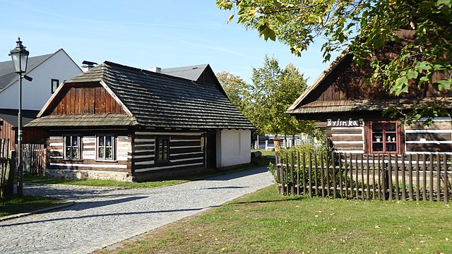
English: Urbanistic complex of human buildings in the town of Hlinsko near the river Chrudimka with of localited name Betlem. It presents the folk architecture in the area of Českomoravská vrchovina. In 1989, significant timbered cottages became part of a museum in the nature entitled Set of Folk Architecture in Vysočina. In 1995 they were proclaimed as a monument reservation of the rural type in town "Hlinsko-Betlem". The same name of the tourist crossroad, marked by the Czech Tourists Club, stands at the entrance to locality in "Čelakovsky" Street. In one of human cottage was the Tourist Information Center Hlinsko (TIC) was established, also with the exposition of folk art (wooden toys, story of wooden doll). On the photo of cottages No. 62 (left) and No. 134 (Herb), green marked tourist trail (with TIC, section of tourist road Hlinsko-Betlem - Town Museum and Gallery). Photo-location: Czechia, Pardubice Region, Hlinsko, street "Čelakovského", "Kameničská" Highlands".
Čeština: Urbanistický celek lidových staveb ve městě Hlinsko u řeky Chrudimky s místním názvem Betlém. Prezentuje lidovou architekturu v oblasti Českomoravské vrchoviny. V roce 1989 se staly významné roubené chalupy součástí muzea v přírodě nazvaného Soubor lidových staveb Vysočina. V roce 1995 byly prohlášeny za památkovou rezervaci vesnického typu s názvem Hlinsko-Betlém. Stejnojmenný rozcestník turistických tras, značených Klubem českých turistů, stojí u vstupu do lokality v Čelakovského ulici. V jedné z chalup bylo zřízeno Turistické informační centrum Hlinsko (TIC), také s expozicí lidové tvorby (dřevěné hračky, příběh dřevěné panenky). Na fotce chalupy čp. 62 (vlevo) a čp. 134 (Bylinka), zeleně značená turistická trasa (s TIC, úsek turistické trasy Hlinsko-Betlém – Městské muzeum a galerie). Foto-lokace: Česko, Pardubický kraj, Hlinsko, Čelakovského ulice, Kameničská vrchovina. |
| Date | |
| Source | Own work |
| Author | Josef Kreuz (PEPan) |
| Camera location | | View this and other nearby images on: OpenStreetMap |
|---|
Externí odkazy
edit
- Turistické informační centrum Hlinsko archive copy at the Wayback Machine
- Památková rezervace Betlém
Licensing
edit
I, the copyright holder of this work, hereby publish it under the following license:
This file is licensed under the Creative Commons Attribution-Share Alike 4.0 International license.
- You are free:
- to share – to copy, distribute and transmit the work
- to remix – to adapt the work
- Under the following conditions:
- attribution – You must give appropriate credit, provide a link to the license, and indicate if changes were made. You may do so in any reasonable manner, but not in any way that suggests the licensor endorses you or your use.
- share alike – If you remix, transform, or build upon the material, you must distribute your contributions under the same or compatible license as the original.
File history
Click on a date/time to view the file as it appeared at that time.
| Date/Time | Thumbnail | Dimensions | User | Comment | |
|---|---|---|---|---|---|
| current | 13:46, 9 October 2017 | | 4,896 × 2,752 (4.48 MB) | PEPan (talk | contribs) | User created page with UploadWizard |
You cannot overwrite this file.
File usage on Commons
There are no pages that use this file.
File usage on other wikis
The following other wikis use this file:
- Usage on cs.wikipedia.org