File:Hlinsko, CZ171210-049.jpg
![File:Hlinsko, CZ171210-049.jpg](https://upload.wikimedia.org/wikipedia/commons/thumb/6/60/Hlinsko%2C_CZ171210-049.jpg/800px-Hlinsko%2C_CZ171210-049.jpg?20171221122244)
Original file (4,896 × 2,752 pixels, file size: 3.99 MB, MIME type: image/jpeg)
Captions
Captions
Summary
editDescriptionHlinsko, CZ171210-049.jpg |
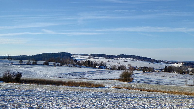
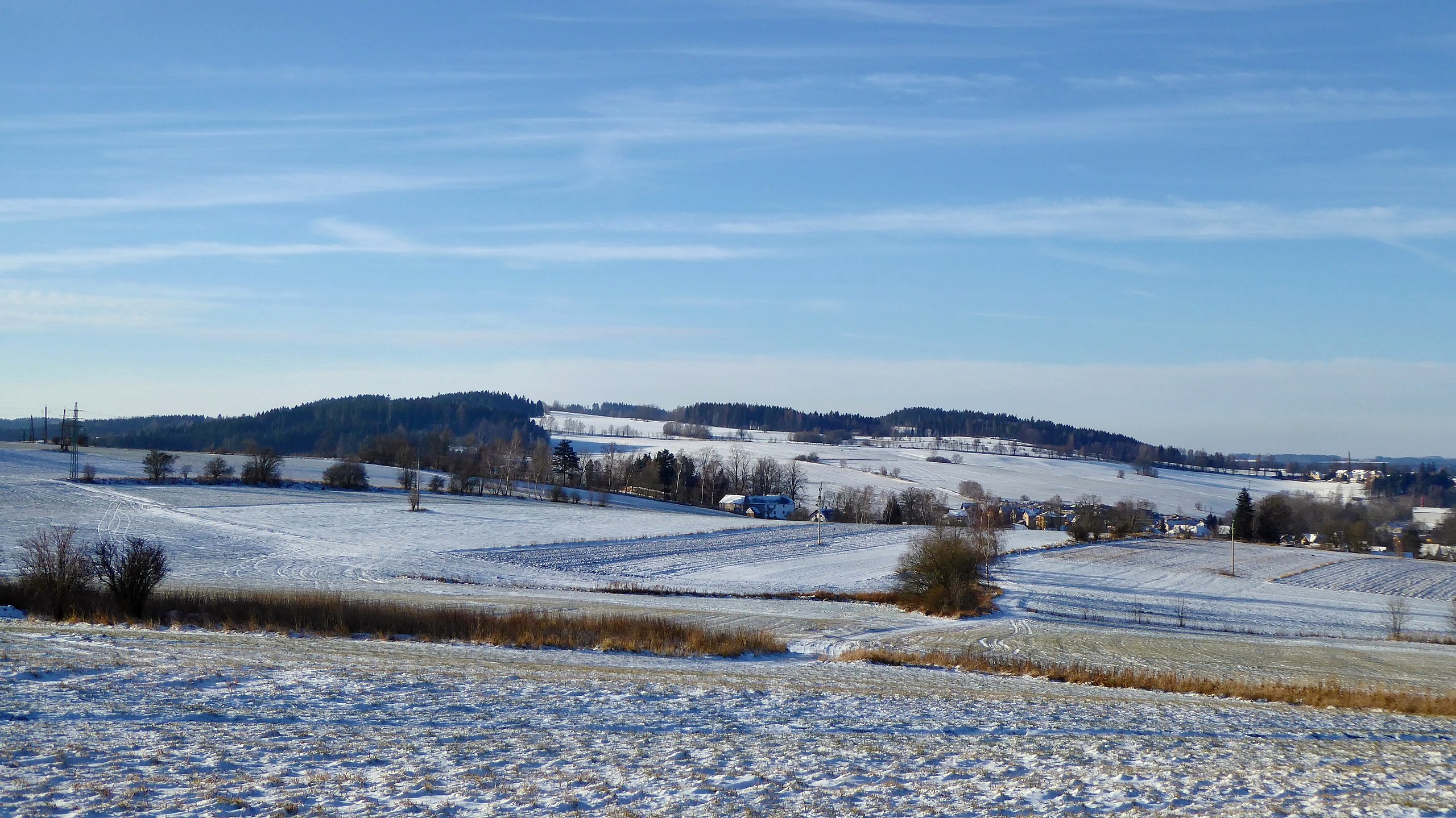
English: Landscape south of the center of town Hlinsko, view from the locality "K Pláňavům" (620 m) on the northwest slope of "Pešava" (697 m). With sufficient snow cover, the site is used for classic skiing. In the summer months, it is wet meadows, in the sloping terrain with the location "In Dolce", from where the water is drawn into the "Blatenský" stream. Geographically, the site is part of the Kameničská Highlands, the geomorphological district of the Iron Mountains. The locality is a specially protected area, part of Protected Landscape Area Žďárské vrchy. In left on the horizon, the wooded peak "K lázním" (679 m) over "Svatojanské" Spas (urban area of the town), to the right of it trigonometric point "U lázní" (655 m) and the hill with name "Na skalce" (637 m) at the level of urn grove with the statue of Master Jan Hus. From the town center to locality "Svatojánské Lázně" lead the tourist routes of the Club of Czech Tourists, yellow marked and also urban route red marked, with name Spa Trail (the routes continues in the direction of the village Studnice). Below the hills, in the valley, the River Chrudimka flows. Buildings is lies in part of town with name "Blatno", in the settlement locality the road No. 343 in the section Hlinsko - village Jeníkov. Photo location: Czechia, Pardubice Region, town Hlinsko, geomorphological district "Kameničská" Highlands, the Iron Mountains.
External link:
Čeština: Krajina na jih od centra města Hlinsko, pohled z lokality K Pláňavům (620 m) na severozápadním úbočí vrchu Pešava (697 m). S dostatkem sněhové pokrývky se místo využívá pro klasické lyžování. V letních měsících se jedná o mokré louky ve svažitém terénu s lokalitou V Dolcích, odkud se voda stahuje do Blatenského potoka. Geograficky je lokalita součástí Kameničské vrchoviny, geomorfologického okrsku Železných hor. Lokalita je zvláště chráněným územím, překrývá ji Chráněná krajinná oblast Žďárské vrchy. Vlevo na obzoru zalesněný vrchol K lázním (679 m) nad Svatojánskými Lázněmi (urbanistický obvod města), od něho vpravo svahová kupa s trigonometrickým bodem U lázní (655 m) a kopec s názvem Na skalce (637 m) na úrovni urnového háje se sochou Mistra Jana Husa. Z centra města do lokality "Svatojánské Lázně" vedou turistické trasy Klubu českých turistů, žlutá značka a také městská trasa červeně značená, s názvem Lázeňská stezka (trasy pokračují směrem na obec Studnice). Pod kopci, v údolí, protéká řeka Chrudimka. Domy leží v části města s názvem Blatno, v sídelní lokalitě silnice č. 343 v úseku Hlinsko - obec Jeníkov. Foto lokace: Česko, Pardubický kraj, Hlinsko, Kameničská vrchovina.
Externí odkaz:
|
Date | |
Source | Own work |
Author | Josef Kreuz (PEPan) |
Camera location | 49° 45′ 46.43″ N, 15° 56′ 09.64″ E ![]() ![]() | View this and other nearby images on: OpenStreetMap | ![]() |
---|
Turistické mapy:
edit- Turistická mapa – Hlinsko a okolí, letecký pohled viz
- Foto lokace – turistická mapa, střed záběru 230°, bod K Pláňavům viz
Licensing
edit![w:en:Creative Commons](https://upload.wikimedia.org/wikipedia/commons/thumb/7/79/CC_some_rights_reserved.svg/90px-CC_some_rights_reserved.svg.png)
![attribution](https://upload.wikimedia.org/wikipedia/commons/thumb/1/11/Cc-by_new_white.svg/24px-Cc-by_new_white.svg.png)
![share alike](https://upload.wikimedia.org/wikipedia/commons/thumb/d/df/Cc-sa_white.svg/24px-Cc-sa_white.svg.png)
- You are free:
- to share – to copy, distribute and transmit the work
- to remix – to adapt the work
- Under the following conditions:
- attribution – You must give appropriate credit, provide a link to the license, and indicate if changes were made. You may do so in any reasonable manner, but not in any way that suggests the licensor endorses you or your use.
- share alike – If you remix, transform, or build upon the material, you must distribute your contributions under the same or compatible license as the original.
File history
Click on a date/time to view the file as it appeared at that time.
Date/Time | Thumbnail | Dimensions | User | Comment | |
---|---|---|---|---|---|
current | 12:22, 21 December 2017 | ![]() | 4,896 × 2,752 (3.99 MB) | PEPan (talk | contribs) | User created page with UploadWizard |
You cannot overwrite this file.
File usage on Commons
There are no pages that use this file.
File usage on other wikis
The following other wikis use this file:
- Usage on cs.wikipedia.org
Metadata
This file contains additional information such as Exif metadata which may have been added by the digital camera, scanner, or software program used to create or digitize it. If the file has been modified from its original state, some details such as the timestamp may not fully reflect those of the original file. The timestamp is only as accurate as the clock in the camera, and it may be completely wrong.
Image title |
|
---|---|
Camera manufacturer | Panasonic |
Camera model | DMC-TZ60 |
Author | Josef Kreuz |
Copyright holder |
|
Exposure time | 1/1,000 sec (0.001) |
F-number | f/3.9 |
ISO speed rating | 100 |
Date and time of data generation | 09:57, 10 December 2017 |
Lens focal length | 7.8 mm |
User comments | EN: Landscape south of the center of town Hlinsko, view from the locality "K Pláňavům" (620 m) on the northwest slope of "Pešava" (697 m). With sufficient snow cover, the site is used for classic skiing. In the summer months, it is wet meadows, in the sloping terrain with the location "In Dolce", from where the water is drawn into the "Blatenský" stream. Geographically, the site is part of the Kameničská Highlands, the geomorphological district of the Iron Mountains. The locality is a specially protected area, part of Protected Landscape Area Žďárské vrchy. In left on the horizon, the wooded peak "K lázním" (679 m) over "Svatojanské" Spas (urban area of the town), to the right of it trigonometric point "U lázní" (655 m) and the hill with name "Na skalce" (637 m) at the level of urn grove with the statue of Master Jan Hus. From the town center to locality "Svatojánské Lázně" lead the tourist routes of the Club of Czech Tourists, yellow marked and also urban route red marked, with name Spa Trail (the routes continues in the direction of the village Studnice). Below the hills, in the valley, the River Chrudimka flows. Buildings is lies in part of town with name "Blatno", in the settlement locality the road No. 343 in the section Hlinsko - village Jeníkov. Photo location: Czechia, Pardubice Region, town Hlinsko, geomorphological district "Kameničská" Highlands, the Iron Mountains.
External link:
CZ: Krajina na jih od centra města Hlinsko, pohled z lokality K Pláňavům (620 m) na severozápadním úbočí vrchu Pešava (697 m). S dostatkem sněhové pokrývky se místo využívá pro klasické lyžování. V letních měsících se jedná o mokré louky ve svažitém terénu s lokalitou V Dolcích, odkud se voda stahuje do Blatenského potoka. Geograficky je lokalita součástí Kameničské vrchoviny, geomorfologického okrsku Železných hor. Lokalita je zvláště chráněným územím, překrývá ji Chráněná krajinná oblast Žďárské vrchy. Vlevo na obzoru zalesněný vrchol K lázním (679 m) nad Svatojánskými Lázněmi (urbanistický obvod města), od něho vpravo svahová kupa s trigonometrickým bodem U lázní (655 m) a kopec s názvem Na skalce (637 m) na úrovni urnového háje se sochou Mistra Jana Husa. Z centra města do lokality "Svatojánské Lázně" vedou turistické trasy Klubu českých turistů, žlutá značka a také městská trasa červeně značená, s názvem Lázeňská stezka (trasy pokračují směrem na obec Studnice). Pod kopci, v údolí, protéká řeka Chrudimka. Domy leží v části města s názvem Blatno, v sídelní lokalitě silnice č. 343 v úseku Hlinsko - obec Jeníkov. Foto lokace: Česko, Pardubický kraj, Hlinsko, Kameničská vrchovina. Externí odkaz:
Turistické mapy:
|
Latitude | 49° 45′ 46.43″ N |
Longitude | 15° 56′ 9.64″ E |
Short title |
|
Label | Yellow |
City shown | Hlinsko |
Compression scheme | Uncompressed |
Pixel composition | RGB |
Orientation | Normal |
Horizontal resolution | 180 dpi |
Vertical resolution | 180 dpi |
Data arrangement | chunky format |
Software used | Zoner Photo Studio 18 |
File change date and time | 11:59, 21 December 2017 |
Y and C positioning | Centered |
Exposure Program | Landscape mode (for landscape photos with the background in focus) |
Exif version | 2.3 |
Date and time of digitizing | 09:57, 10 December 2017 |
Meaning of each component |
|
Image compression mode | 4 |
APEX exposure bias | 0 |
Maximum land aperture | 3.9296875 APEX (f/3.9) |
Metering mode | Pattern |
Light source | Unknown |
Flash | Flash did not fire, compulsory flash suppression |
Supported Flashpix version | 1 |
Color space | sRGB |
Sensing method | One-chip color area sensor |
File source | Digital still camera |
Scene type | A directly photographed image |
Custom image processing | Normal process |
Exposure mode | Auto exposure |
White balance | Auto white balance |
Digital zoom ratio | 0 |
Focal length in 35 mm film | 49 mm |
Scene capture type | Standard |
Scene control | None |
Contrast | Normal |
Saturation | Normal |
Sharpness | Normal |
GPS time (atomic clock) | 08:56 |
Receiver status | Measurement in progress |
Measurement mode | 2-dimensional measurement |
Measurement precision | Moderate (0.7) |
Geodetic survey data used | WGS-84 |
Name of GPS area | 䌀栀爀甀搀椀洀 |
GPS date | 10 December 2017 |
GPS tag version | 0.0.3.2 |
Keywords | Hlinsko |
Writer | Josef Kreuz |
Province or state shown | Pardubický kraj |
Country shown | Česko |
Code for country shown | CZ |
Sublocation of city shown | K Pláňavům |