File:Hobben und Ante Flus 1645.jpg

Size of this preview: 752 × 600 pixels. Other resolutions: 301 × 240 pixels | 602 × 480 pixels | 963 × 768 pixels | 1,280 × 1,021 pixels | 2,560 × 2,041 pixels | 4,339 × 3,460 pixels.
Original file (4,339 × 3,460 pixels, file size: 4.38 MB, MIME type: image/jpeg)
Captions
Captions
Add a one-line explanation of what this file represents
Summary edit
| Description |
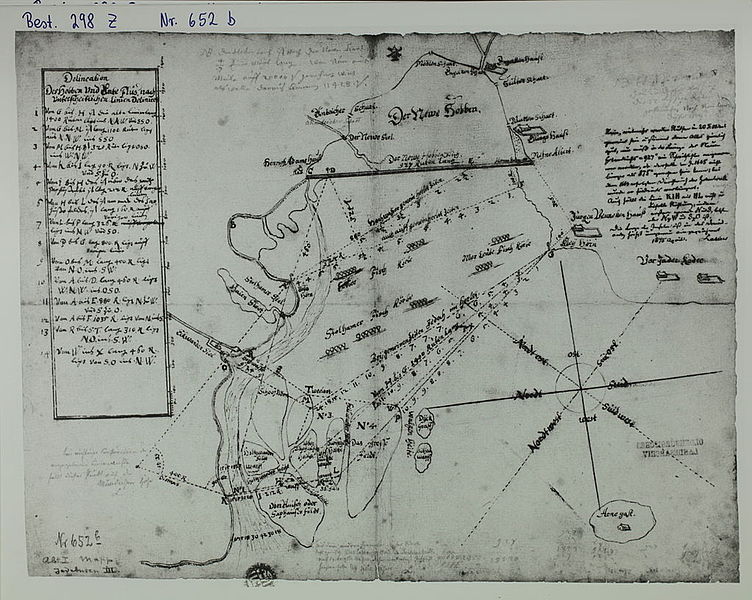
Deutsch: Die Inseln „Oberahnesche Felder" im Jadebusen, der verlandete und gerade fertig abgedeichte Meeresarm „Hoben" (das „Lockfleth" nach dessen Unterbrechung), der Ante- = Ahne-Fluss als Priel im Jadebusen; Messlinien und Wassertiefen, aus denen sich ein Tidenhub von 12 Fuß ergibt. Die Karte hier ist exakter genordet und enthält mehr Messlinien, als die unten verlinkte (Archiv Nr. 652 c). Eine dort eingezeichnete Messlinie ist hier als die "alte" bezeichnet. Damit ist die hier vorliegende Version als die jüngere und geometrisch verbesserte zu betrachten. Die Insel Arn(e)gast (rechts unten) ist in beiden Karten an den Rand geklemmt, wesentlich näher und wesentlich kleiner dargestellt, als in anderen Karten desselben Autors English: The islands of Oberahnesche Felder in Jade Bight, in the background the recently closed inlet of Hob(b)en (previously called Lockfleth), and the channel Ahne Flus(s) among the foreshore of Jade Bight, the Island of Arn(e)gast is presented much nearer and much smaller than in other maps of the same author; furthermore distance lines and depths are marked, showing a tide range of 12 feet. |
| Date | |
| Source | Landesarchiv Oldenburg, Best. 298 Nr. 652 b |
| Author | original map by Johann Conrad Musculus, upload by Ulamm (talk) 14:30, 14 February 2014 (UTC) |
| Other versions | another historical version of this map (Oldenburg archive n° 652 c) with another choice of details. e. g. "Alte Ahne" river as former eastern affluent of Atne/Ahne |
Licensing edit
|
This work is in the public domain in its country of origin and other countries and areas where the copyright term is the author's life plus 100 years or fewer. | |
| This file has been identified as being free of known restrictions under copyright law, including all related and neighboring rights. | |
File history
Click on a date/time to view the file as it appeared at that time.
| Date/Time | Thumbnail | Dimensions | User | Comment | |
|---|---|---|---|---|---|
| current | 14:31, 28 November 2014 | | 4,339 × 3,460 (4.38 MB) | Ulamm (talk | contribs) | brighter |
| 18:37, 1 March 2014 |  | 4,339 × 3,460 (1.27 MB) | Ulamm (talk | contribs) | == {{int:filedesc}} == {{Information |Description={{de|1=Die Inseln „Oberahnesche Felder" im Jadebusen, der verlandete und gerade fertig abgedeichte Meeresarm „Hoben" (das „Lockfleth" nach dessen Unterbrechung), der Ahnefluss als Priel im Jadebus... |
You cannot overwrite this file.
File usage on Commons
There are no pages that use this file.
File usage on other wikis
The following other wikis use this file:
- Usage on de.wikipedia.org