File:Hochasien Gliederung.jpg

Size of this preview: 800 × 561 pixels. Other resolutions: 320 × 224 pixels | 640 × 448 pixels | 1,024 × 717 pixels | 1,280 × 897 pixels | 2,235 × 1,566 pixels.
Original file (2,235 × 1,566 pixels, file size: 3.98 MB, MIME type: image/jpeg)
Captions
Captions
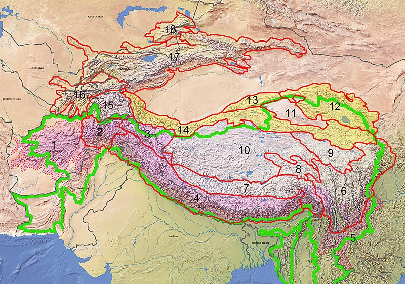
Relief map of High Asia with delineation of the major mountain ranges
Summary edit
| Description |
Landkarte der Region "Hochasien" mit den großen Gebirgszügen
|
| Date | |
| Source |
Own work Grundkarte erstellt mit geo.dianacht.de, Reliefkarte (Lizenz CC-BY) Grenzverläufe der Gebirge: vorwiegend mit Hilfe von Mountain Ranges von Global Mountain Biodiversity Assessment |
| Author | Fährtenleser |
Licensing edit
I, the copyright holder of this work, hereby publish it under the following licenses:

|
Permission is granted to copy, distribute and/or modify this document under the terms of the GNU Free Documentation License, Version 1.2 or any later version published by the Free Software Foundation; with no Invariant Sections, no Front-Cover Texts, and no Back-Cover Texts. A copy of the license is included in the section entitled GNU Free Documentation License. |
This file is licensed under the Creative Commons Attribution-Share Alike Attribution-Share Alike 4.0 International, 3.0 Unported, 2.5 Generic, 2.0 Generic and 1.0 Generic license.
- You are free:
- to share – to copy, distribute and transmit the work
- to remix – to adapt the work
- Under the following conditions:
- attribution – You must give appropriate credit, provide a link to the license, and indicate if changes were made. You may do so in any reasonable manner, but not in any way that suggests the licensor endorses you or your use.
- share alike – If you remix, transform, or build upon the material, you must distribute your contributions under the same or compatible license as the original.
You may select the license of your choice.
File history
Click on a date/time to view the file as it appeared at that time.
| Date/Time | Thumbnail | Dimensions | User | Comment | |
|---|---|---|---|---|---|
| current | 18:48, 18 January 2021 | | 2,235 × 1,566 (3.98 MB) | Fährtenleser (talk | contribs) | {{Information |Description=Landkarte der Region "Hochasien" mit den großen Gebirgszügen |Source={{own}} |Date=2021-01-18 |Author= Fährtenleser |Permission= |other_versions= }} Category:Maps of mountain ranges of Asia |
You cannot overwrite this file.
File usage on Commons
There are no pages that use this file.
File usage on other wikis
The following other wikis use this file:
- Usage on de.wikipedia.org
- Usage on it.wikipedia.org
- Usage on uk.wikipedia.org