File:Holy Roman Empire ca.1600.svg

Size of this PNG preview of this SVG file: 482 × 298 pixels. Other resolutions: 320 × 198 pixels | 640 × 396 pixels | 1,024 × 633 pixels | 1,280 × 791 pixels | 2,560 × 1,583 pixels.
Original file (SVG file, nominally 482 × 298 pixels, file size: 342 KB)
Captions
Captions
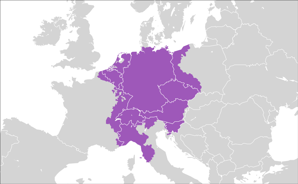
The Holy Roman Empire
Summary
edit| Description |
English: The Holy Roman Empire around AD 1600. |
| Date | |
| Source | Own work, based on File:Holyromanempire.png |
| Author | Ssolbergj |

Licensing
edit
I, the copyright holder of this work, hereby publish it under the following licenses:
This file is licensed under the Creative Commons Attribution-Share Alike 3.0 Unported license.
- You are free:
- to share – to copy, distribute and transmit the work
- to remix – to adapt the work
- Under the following conditions:
- attribution – You must give appropriate credit, provide a link to the license, and indicate if changes were made. You may do so in any reasonable manner, but not in any way that suggests the licensor endorses you or your use.
- share alike – If you remix, transform, or build upon the material, you must distribute your contributions under the same or compatible license as the original.

|
Permission is granted to copy, distribute and/or modify this document under the terms of the GNU Free Documentation License, Version 1.2 or any later version published by the Free Software Foundation; with no Invariant Sections, no Front-Cover Texts, and no Back-Cover Texts. A copy of the license is included in the section entitled GNU Free Documentation License. |
You may select the license of your choice.
File history
Click on a date/time to view the file as it appeared at that time.
| Date/Time | Thumbnail | Dimensions | User | Comment | |
|---|---|---|---|---|---|
| current | 02:28, 20 August 2017 | | 482 × 298 (342 KB) | Alphathon (talk | contribs) | More minor corrections |
| 21:42, 19 August 2017 |  | 482 × 298 (261 KB) | Alphathon (talk | contribs) | More corrections (mostly removal of territory in the Netherlands what hadn't yet been reclaimed from the sea) | |
| 14:32, 18 August 2017 |  | 482 × 298 (255 KB) | Alphathon (talk | contribs) | Corrected numerous inaccuracies | |
| 21:34, 18 January 2010 |  | 482 × 298 (336 KB) | Ssolbergj (talk | contribs) | fix | |
| 15:54, 15 January 2009 |  | 482 × 298 (338 KB) | Ssolbergj (talk | contribs) | {{Information |Description={{en|1=The Holy Roman Empire around year 1600 AD.}} |Source=Own work by uploader |Author=Ssolbergj |Date=15 January 2009 |Permission= |other_versions= }} <!--{{ImageUpload|full}}--> [[Category:Maps of the Hol |
You cannot overwrite this file.
File usage on Commons
The following 4 pages use this file:
.svg)
File usage on other wikis
The following other wikis use this file:
- Usage on af.wikipedia.org
- Usage on an.wikipedia.org
- Usage on ar.wikipedia.org
- Usage on arz.wikipedia.org
- Usage on ast.wikipedia.org
- Usage on azb.wikipedia.org
- Usage on bat-smg.wikipedia.org
- Usage on br.wikipedia.org
- Usage on bs.wikipedia.org
- Usage on ckb.wikipedia.org
- Usage on da.wikipedia.org
- Usage on el.wikipedia.org
- Usage on en.wikipedia.org
- Usage on en.wiktionary.org
- Usage on es.wikipedia.org
- Usage on et.wikipedia.org
- Usage on eu.wikipedia.org
- Usage on fa.wikipedia.org
- Usage on fiu-vro.wikipedia.org
- Usage on fi.wikipedia.org
- Usage on fo.wikipedia.org
- Usage on fr.wikipedia.org
- Usage on gv.wikipedia.org
- Usage on hak.wikipedia.org
- Usage on hu.wikipedia.org
- Usage on hy.wikipedia.org
- Usage on id.wikipedia.org
- Usage on ilo.wikipedia.org
- Usage on incubator.wikimedia.org
- Usage on io.wikipedia.org
- Usage on ja.wikipedia.org
- Usage on jv.wikipedia.org
- Usage on ka.wikipedia.org
- Usage on ko.wikipedia.org
- Usage on krc.wikipedia.org
- Usage on ky.wikipedia.org
- Usage on lfn.wikipedia.org
- Usage on lv.wikipedia.org
- Usage on mk.wikipedia.org
- Usage on ml.wikipedia.org
View more global usage of this file.