File:Homo Sapiens in Europe - magdalenian distribution map-de.svg

Size of this PNG preview of this SVG file: 800 × 460 pixels. Other resolutions: 320 × 184 pixels | 640 × 368 pixels | 1,024 × 589 pixels | 1,280 × 736 pixels | 2,560 × 1,472 pixels | 2,000 × 1,150 pixels.
Original file (SVG file, nominally 2,000 × 1,150 pixels, file size: 121 KB)
Captions
Captions
Add a one-line explanation of what this file represents
| Description |
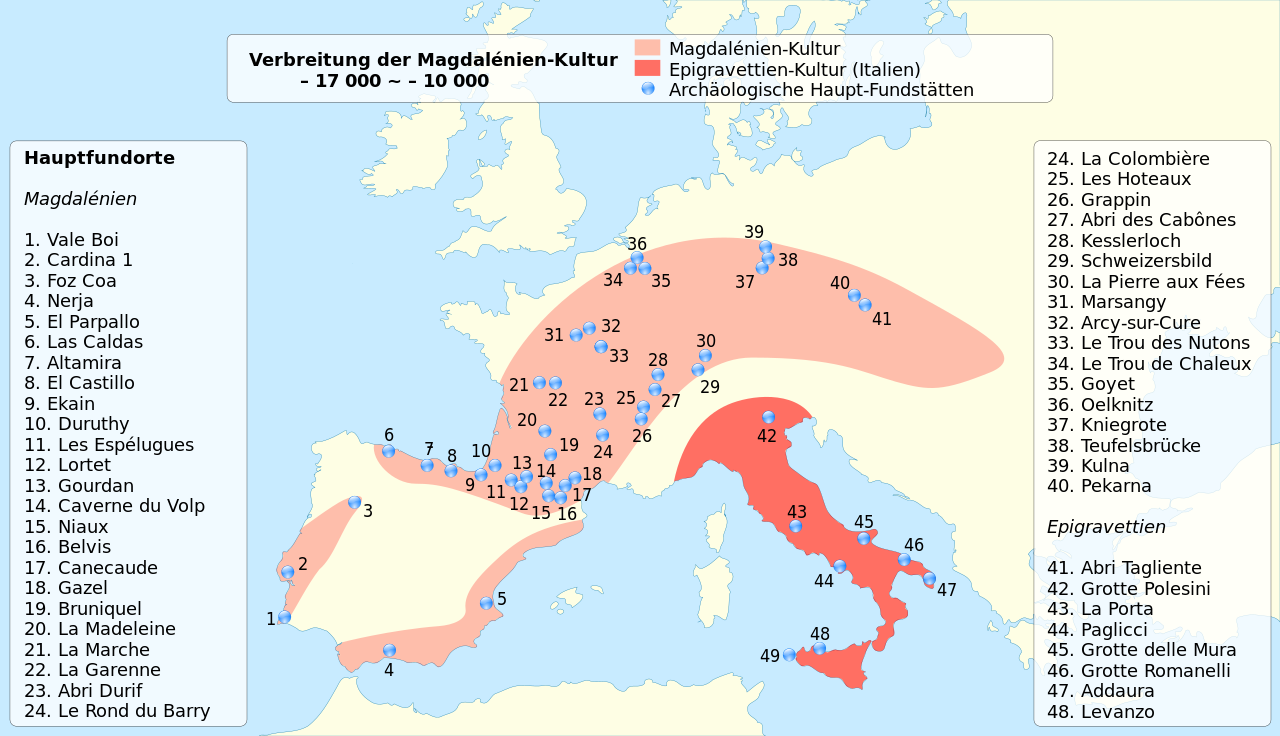
Français : Carte de localisation de la culture Homo Sapiens du Magdalénien, il y a environ entre 19 000 et 12 000 ans. English: Location map of Homo Sapiens during Magdalenian culture, between 19,000 ~ 12,000 BP. German version. |
| Date | (UTC) |
| Source | |
| Author |
|
| This is a retouched picture, which means that it has been digitally altered from its original version. Modifications: deutsche Übersetzung/traduction allemand/German translation. The original can be viewed here: Homo Sapiens in Europe - magdalenian distribution map-fr.svg:
|
I, the copyright holder of this work, hereby publish it under the following licenses:
| This file is licensed under the Creative Commons Attribution-Share Alike 3.0 Unported license. | ||
| ||
| This licensing tag was added to this file as part of the GFDL licensing update. |

|
Permission is granted to copy, distribute and/or modify this document under the terms of the GNU Free Documentation License, Version 1.2 or any later version published by the Free Software Foundation; with no Invariant Sections, no Front-Cover Texts, and no Back-Cover Texts. A copy of the license is included in the section entitled GNU Free Documentation License. |
You may select the license of your choice.
Original upload log edit
This image is a derivative work of the following images:
- File:Homo_Sapiens_in_Europe_-_magdalenian_distribution_map-fr.svg licensed with Cc-by-sa-3.0-migrated, GFDL
- 2009-11-08T19:46:47Z Sémhur 2000x1150 (123625 Bytes) 2 - 19000 BP, not 26000
- 2009-11-08T19:40:48Z Sémhur 2000x1150 (123618 Bytes) == {{int:filedesc}} == {{Information |Description= {{en|Location map of Homo Sapiens during [[:en:Magdalenian|Magdalenian]] culture, between 24,000 ~ 12,000 BP. French version.}} {{fr|Carte de localisation de la culture Homo
Uploaded with derivativeFX
File history
Click on a date/time to view the file as it appeared at that time.
| Date/Time | Thumbnail | Dimensions | User | Comment | |
|---|---|---|---|---|---|
| current | 10:57, 12 June 2021 | | 2,000 × 1,150 (121 KB) | Sémhur (talk | contribs) | font size |
| 10:55, 12 June 2021 |  | 2,000 × 1,150 (121 KB) | Sémhur (talk | contribs) | + 20 La Madeleine | |
| 19:39, 27 March 2018 |  | 2,000 × 1,150 (126 KB) | Sémhur (talk | contribs) | + 32 - Arcy-sur-Cure | |
| 00:03, 25 March 2010 |  | 2,000 × 1,150 (122 KB) | Uwe Dedering (talk | contribs) | font, symbols | |
| 17:09, 6 February 2010 |  | 2,000 × 1,150 (136 KB) | Furfur (talk | contribs) | Positionspunkte korrigiert, leider ist das Aussehen der Punkte im Vergleich zum Original unschöner ... | |
| 16:51, 6 February 2010 |  | 2,000 × 1,150 (136 KB) | Furfur (talk | contribs) | {{Information |Description={{de|Verbreitung der Magdalénien-Kultur im Jungpaläolithikum in Europa.}} {{fr|Carte de localisation de la culture Homo Sapiens du Magdalénien, il y a envir |
You cannot overwrite this file.
File usage on Commons
The following page uses this file:
File usage on other wikis
The following other wikis use this file:
- Usage on ar.wikipedia.org
- Usage on de.wikipedia.org
- Usage on eo.wiktionary.org
- Usage on he.wikipedia.org
- Usage on ka.wikipedia.org
- Usage on lfn.wikipedia.org
- Usage on lt.wikipedia.org
- Usage on lv.wikipedia.org
- Usage on no.wikipedia.org
- Usage on oc.wikipedia.org
- Usage on pl.wikipedia.org
- Usage on ro.wikipedia.org
- Usage on ru.wikipedia.org
- Usage on zh.wikipedia.org