File:HomochittoRiver1974.jpg

No higher resolution available.
HomochittoRiver1974.jpg (498 × 503 pixels, file size: 38 KB, MIME type: image/jpeg)
Captions
Captions
Add a one-line explanation of what this file represents
Summary edit
| Description |
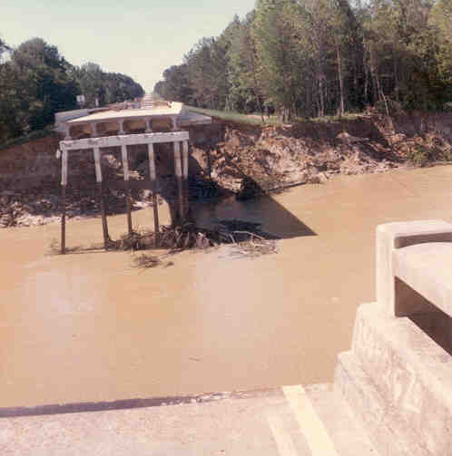
English: Mississippi Highway 33 bridge failure near USGS no. 07292500 station no. 07292500 just north of Rosetta, caused by the April 1974 flood on the Homochitto River. |
| Date | |
| Source |
Transferred from en.wikipedia to Commons. (Original text: USGS Surface Water Photo Gallery, item 17 19) |
| Author | Unknown (submitted by Van Wilson, Mississippi) |
| Permission (Reusing this file) |
Public Domain |
Licensing edit
This image is in the public domain in the United States because it only contains materials that originally came from the United States Geological Survey, an agency of the United States Department of the Interior. For more information, see the official USGS copyright policy.
|
Original upload log edit
The original description page was here. All following user names refer to en.wikipedia.
| Date/Time | Dimensions | User | Comment |
|---|---|---|---|
| 2008-09-03 22:58 | 498×503× (39059 bytes) | Suntag |
File history
Click on a date/time to view the file as it appeared at that time.
| Date/Time | Thumbnail | Dimensions | User | Comment | |
|---|---|---|---|---|---|
| current | 20:55, 1 June 2020 | | 498 × 503 (38 KB) | Krok6kola (talk | contribs) | Transferred from en.wikipedia via #commonshelper |
You cannot overwrite this file.
File usage on Commons
The following page uses this file:
File usage on other wikis
The following other wikis use this file:
- Usage on en.wikipedia.org
- Usage on it.wikipedia.org
- Usage on it.wikibooks.org
- Usage on it.wikiversity.org
- Usage on www.wikidata.org