File:Horní ratajský rybník, CZ171018-001.jpg
Original file (4,754 × 2,705 pixels, file size: 5.26 MB, MIME type: image/jpeg)
Captions
Summary
editDescriptionHorní ratajský rybník, CZ171018-001.jpg |
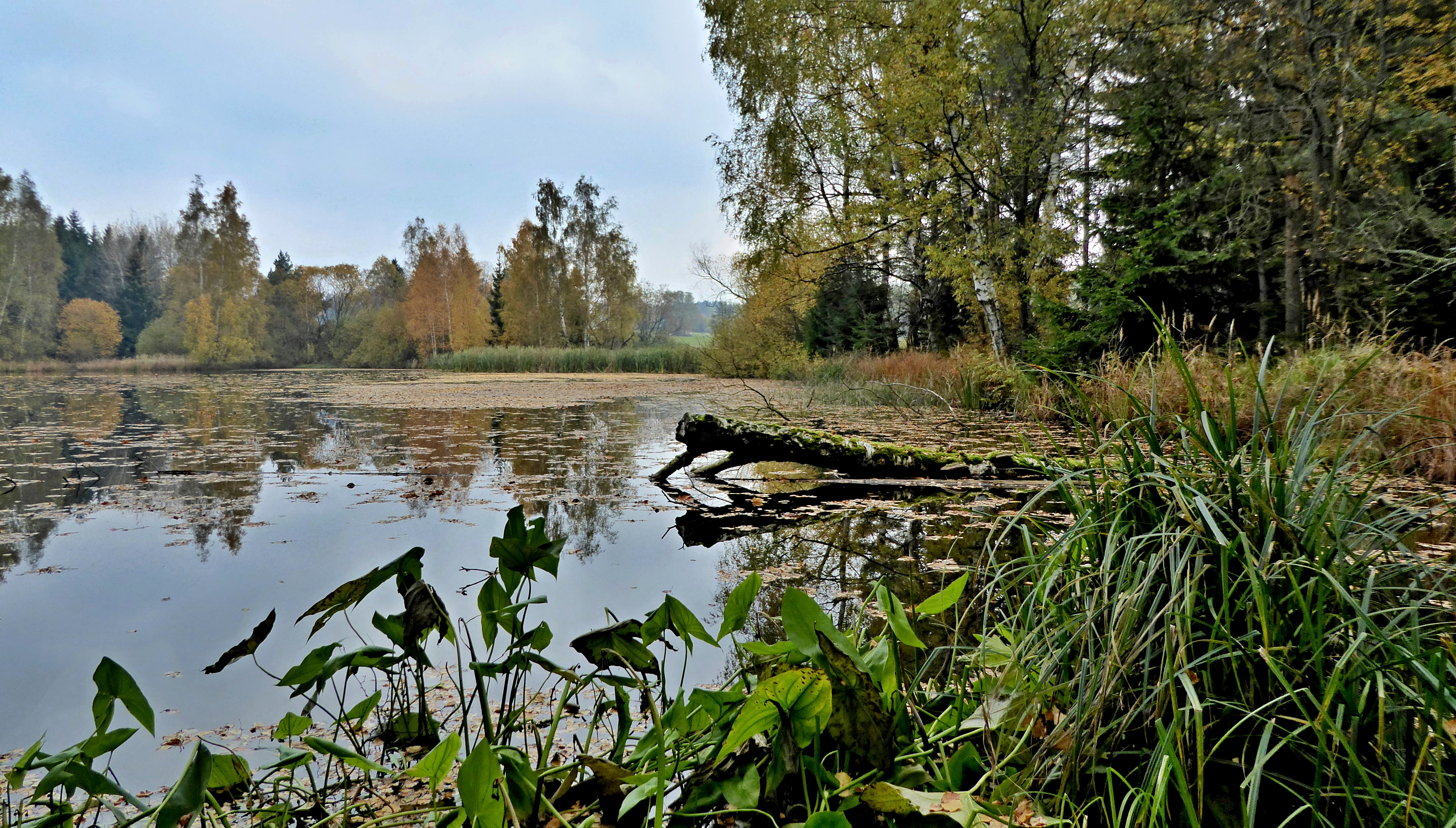
English: "Horní ratajský" pond is the geographical name of a pond with an area of 1.6714 ha in the landscape area of Iron Mountains on the cadastral territory of town Hlinsko in the Chrudim district belonging to the Pardubice Region in the Czech Republic. The pond is part of the pond system "Ratajské" ponds, also of natural monument of the same name and European-important locality. Autumn time means fallen leaves on the surface of the pond and drying out vegetation on the shore. Photo location: Czechia, Pardubice Region, town Hlinsko, "Horní ratajský" pond (60°).
Čeština: Horní ratajský rybník je zeměpisný název rybníku o rozloze 1,6714 ha v krajinné oblasti Železných hor na katastrálním území města Hlinsko v okrese Chrudim náležejícím do Pardubického kraje v České republice. Rybník je součást rybniční soustavy Ratajské rybníky, také přírodní památky stejného jména a evropsky významné lokality. Podzimní čas znamená spadané listí na hladině rybníku a usychání vegetace na břehu. Foto lokace: Česko, Pardubický kraj, město Hlinsko, Ratajské rybníky, Horní ratajský rybník (60°), Kameničská vrchovina. |
Date | |
Source | Own work |
Author | Josef Kreuz (PEPan) |
Camera location | 49° 46′ 09.62″ N, 15° 56′ 11.18″ E | View this and other nearby images on: OpenStreetMap | 49.769340; 15.936438 |
---|
Faktografie
editVybudován kolem roku 1855, uváděn již na mapách tzv. II. vojenského mapování v Čechách. Zdrojem vody jsou bezejmenné vodoteče, zdrojnice Blatenského potoku, pravostranného přítoku řeky Chrudimky v části města Blatno (odtud název potoku). Málo vydatné vodoteče napájející rybniční soustavu pramení ve svahu železnohorského hřbetu pod vrcholem Čertovina (655 m n. m.). Místní název rybníku "Horní rataják", hloubka až 1,7 m, největší plochou v průtočné rybniční soustavě (Prostřední rataják o rozloze 0,726 ha a Dolní rataják o rozloze 1,3358 ha), v péči rybářské organizace v Hlinsku.
Externí odkazy
edit- Přírodní památka Ratajské rybníky
- Evropsky významná lokalita Ratajské rybníky
- Ratajské rybníky – heslo CS Wikipedie
Licensing
edit- You are free:
- to share – to copy, distribute and transmit the work
- to remix – to adapt the work
- Under the following conditions:
- attribution – You must give appropriate credit, provide a link to the license, and indicate if changes were made. You may do so in any reasonable manner, but not in any way that suggests the licensor endorses you or your use.
- share alike – If you remix, transform, or build upon the material, you must distribute your contributions under the same or compatible license as the original.
File history
Click on a date/time to view the file as it appeared at that time.
Date/Time | Thumbnail | Dimensions | User | Comment | |
---|---|---|---|---|---|
current | 13:00, 21 October 2017 | 4,754 × 2,705 (5.26 MB) | PEPan (talk | contribs) | User created page with UploadWizard |
You cannot overwrite this file.
File usage on Commons
There are no pages that use this file.
File usage on other wikis
The following other wikis use this file:
- Usage on cs.wikipedia.org
Metadata
This file contains additional information such as Exif metadata which may have been added by the digital camera, scanner, or software program used to create or digitize it. If the file has been modified from its original state, some details such as the timestamp may not fully reflect those of the original file. The timestamp is only as accurate as the clock in the camera, and it may be completely wrong.
Camera manufacturer | Panasonic |
---|---|
Camera model | DMC-TZ60 |
Author | Josef Kreuz |
Copyright holder |
|
Exposure time | 1/250 sec (0.004) |
F-number | f/3.3 |
ISO speed rating | 200 |
Date and time of data generation | 09:17, 18 October 2017 |
Lens focal length | 4.3 mm |
User comments | EN: "Horní ratajský" pond is the geographical name of a pond with an area of 1.6714 ha in the landscape area of Iron Mountains on the cadastral territory of town Hlinsko in the Chrudim district belonging to the Pardubice Region in the Czech Republic. The pond is part of the pond system "Ratajské" ponds, also of natural monument of the same name and European-important locality. Autumn time means fallen leaves on the surface of the pond and drying out vegetation on the shore. Photo location: Czechia, Pardubice Region, town Hlinsko, "Horní ratajský" pond (60°).
CZ: Horní ratajský rybník je zeměpisný název rybníku o rozloze 1,6714 ha v krajinné oblasti Železných hor na katastrálním území města Hlinsko v okrese Chrudim náležejícím do Pardubického kraje v České republice. Rybník je součást rybniční soustavy Ratajské rybníky, také přírodní památky stejného jména a evropsky významné lokality. Podzimní čas znamená spadané listí na hladině rybníku a usychání vegetace na břehu. Foto lokace: Česko, Pardubický kraj, město Hlinsko, Ratajské rybníky, Horní ratajský rybník (60°), Kameničská vrchovina. Faktografie: Vybudován kolem roku 1855, uváděn již na mapách tzv. II. vojenského mapování v Čechách. Zdrojem vody jsou bezejmenné vodoteče, zdrojnice Blatenského potoku, pravostranného přítoku řeky Chrudimky v části města Blatno (odtud název potoku). Málo vydatné vodoteče napájející rybniční soustavu pramení ve svahu železnohorského hřbetu pod vrcholem Čertovina (655 m n. m.). Místní název rybníku "Horní rataják", hloubka až 1,7 m, největší plochou v průtočné rybniční soustavě (Prostřední rataják o rozloze 0,726 ha a Dolní rataják o rozloze 1,3358 ha), v péči rybářské organizace v Hlinsku. Externí odkazy:
|
Latitude | 49° 46′ 9.62″ N |
Longitude | 15° 56′ 11.18″ E |
Short title |
|
Image title |
|
Label | Yellow |
City shown | Hlinsko |
Compression scheme | Uncompressed |
Pixel composition | RGB |
Orientation | Normal |
Horizontal resolution | 180 dpi |
Vertical resolution | 180 dpi |
Data arrangement | chunky format |
Software used | Zoner Photo Studio 18 |
File change date and time | 14:56, 21 October 2017 |
Y and C positioning | Centered |
Exposure Program | Normal program |
Exif version | 2.3 |
Date and time of digitizing | 09:17, 18 October 2017 |
Meaning of each component |
|
Image compression mode | 4 |
APEX exposure bias | 0 |
Maximum land aperture | 3.4453125 APEX (f/3.3) |
Metering mode | Pattern |
Light source | Unknown |
Flash | Flash did not fire, compulsory flash suppression |
Supported Flashpix version | 1 |
Color space | sRGB |
Sensing method | One-chip color area sensor |
File source | Digital still camera |
Scene type | A directly photographed image |
Custom image processing | Normal process |
Exposure mode | Auto bracket |
White balance | Auto white balance |
Digital zoom ratio | 0 |
Focal length in 35 mm film | 27 mm |
Scene capture type | Standard |
Scene control | Low gain up |
Contrast | Normal |
Saturation | Normal |
Sharpness | Normal |
GPS time (atomic clock) | 00:00 |
Receiver status | Measurement interoperability |
Measurement mode | 2-dimensional measurement |
Measurement precision | Excellent (0) |
Geodetic survey data used | WGS-84 |
GPS date | 0000:00:00 |
GPS tag version | 0.0.3.2 |
Writer | Josef Kreuz |
Province or state shown | Pardubický kraj |
Country shown | Česko |
Code for country shown | CZ |
Sublocation of city shown | Horní ratajský rybník |