File:Horten Ho229 V3 ‘T2-490’ - 51174624411.jpg

Original file (4,520 × 3,013 pixels, file size: 10.43 MB, MIME type: image/jpeg)
Captions
Captions
Summary edit
| Description |
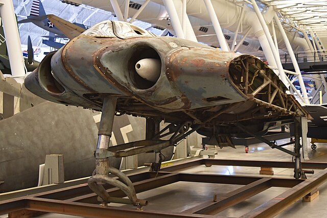
English: c/n V3
The Ho229 was a jet-powered all-wing fighter/bomber intended for Luftwaffe service during WW2. Through a series of research gliders, Horten had successfully proved that ‘flying-wing’ aircraft were practical and this was to be their first operational design. It was a single-seat twin-jet armed with either cannons or a bomb load of 2,200lb. The first prototype, the H.IX V1, was successfully flown as a glider, with the first flight taking place on 1st March 1944. The second aircraft, the H.IX V2, was powered by two Junkers Jumo 004B turbojets , but problems with the supply of engines meant it did not fly until 2nd February 1945. It carried out two successful test flights during which it showed that it handled well and had the potential to reach very high speeds, but crashed on its third flight after an engine failed and caught fire. This is the third prototype, the V-3, and was to be the first to carry armament, but it was not completed before the end of the war. It was built at the Gothaer Waggonfabrik (Gotha) factory in Friedrichroda, and is therefore technically a Go229, although it is usually referred to as the Ho229. Although incomplete, it was shipped to the United States for and given the Foreign Evaluation identity FE-490, which was later changed to T2-490. It arrived at Silver Hill, Maryland, for storage in 1952 and was officially transferred to the Smithsonian Institute in 1960. Preserved in an unrestored condition, it is seen on display in the Steven F. Udvar Hazy Center as part of the National Air and Space Museum. Washington Dulles International Airport, Chantilly, Virginia 15th March 2018 |
| Date | |
| Source | https://www.flickr.com/photos/65001151@N03/51174624411/ |
| Author | HawkeyeUK |
| Camera location | | View this and other nearby images on: OpenStreetMap |
|---|
Licensing edit
- You are free:
- to share – to copy, distribute and transmit the work
- to remix – to adapt the work
- Under the following conditions:
- attribution – You must give appropriate credit, provide a link to the license, and indicate if changes were made. You may do so in any reasonable manner, but not in any way that suggests the licensor endorses you or your use.
- share alike – If you remix, transform, or build upon the material, you must distribute your contributions under the same or compatible license as the original.
| This image was originally posted to Flickr by HawkeyeUK at https://flickr.com/photos/65001151@N03/51174624411. It was reviewed on 28 May 2021 by FlickreviewR 2 and was confirmed to be licensed under the terms of the cc-by-sa-2.0. |
File history
Click on a date/time to view the file as it appeared at that time.
| Date/Time | Thumbnail | Dimensions | User | Comment | |
|---|---|---|---|---|---|
| current | 22:03, 28 May 2021 | | 4,520 × 3,013 (10.43 MB) | Ser Amantio di Nicolao (talk | contribs) | Uploaded a work by HawkeyeUK from https://www.flickr.com/photos/65001151@N03/51174624411/ with UploadWizard |
You cannot overwrite this file.
File usage on Commons
The following 2 pages use this file:
.jpg&redirect=no)
File usage on other wikis
The following other wikis use this file:
- Usage on lt.wikipedia.org