File:House at Wormald Green - geograph.org.uk - 806548.jpg
No higher resolution available.
House_at_Wormald_Green_-_geograph.org.uk_-_806548.jpg (640 × 427 pixels, file size: 75 KB, MIME type: image/jpeg)
Captions
Captions
Add a one-line explanation of what this file represents
Summary
edit
| Description |
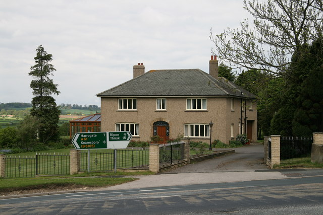
English: House at Wormald Green A disused railway cutting was used as a refuse tip but the resultant build up of gas caused an explosion which severely damaged this nearby house at the junction of Station Lane with the A61. The house has been stabilised and the tip is now vented to allow the gases to escape. |
| Date | |
| Source | From geograph.org.uk |
| Author | David Rogers |
| Attribution (required by the license) | David Rogers / House at Wormald Green / |
| Camera location | | View this and other nearby images on: OpenStreetMap |
|---|
_heading:0.00&language=en)
| Object location | | View this and other nearby images on: OpenStreetMap |
|---|
_heading:0.00&language=en)
Licensing
edit

|
This image was taken from the Geograph project collection. See this photograph's page on the Geograph website for the photographer's contact details. The copyright on this image is owned by David Rogers and is licensed for reuse under the Creative Commons Attribution-ShareAlike 2.0 license.
|
This file is licensed under the Creative Commons Attribution-Share Alike 2.0 Generic license.
Attribution: David Rogers
- You are free:
- to share – to copy, distribute and transmit the work
- to remix – to adapt the work
- Under the following conditions:
- attribution – You must give appropriate credit, provide a link to the license, and indicate if changes were made. You may do so in any reasonable manner, but not in any way that suggests the licensor endorses you or your use.
- share alike – If you remix, transform, or build upon the material, you must distribute your contributions under the same or compatible license as the original.
File history
Click on a date/time to view the file as it appeared at that time.
| Date/Time | Thumbnail | Dimensions | User | Comment | |
|---|---|---|---|---|---|
| current | 08:34, 20 February 2011 | | 640 × 427 (75 KB) | GeographBot (talk | contribs) | == {{int:filedesc}} == {{Information |description={{en|1=House at Wormald Green A disused railway cutting was used as a refuse tip but the resultant build up of gas caused an explosion which severely damaged this nearby house at the junction of Station La |
You cannot overwrite this file.
File usage on Commons
There are no pages that use this file.