File:Hruby Jesenik CZ I4C-7.png

Size of this preview: 800 × 498 pixels. Other resolutions: 320 × 199 pixels | 640 × 398 pixels | 1,209 × 752 pixels.
Original file (1,209 × 752 pixels, file size: 49 KB, MIME type: image/png)
Captions
Captions
Add a one-line explanation of what this file represents
Summary
edit| Description |
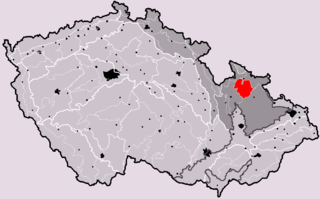
Čeština: Poloha geomorfologického celku Hrubý Jeseník v rámci České republiky.
|
| Date | |
| Source | Own work, based on File:Czech_Republic_geomorphological_division_map_blank.png |
| Author | User:Miaow Miaow |
| Permission (Reusing this file) |
PD-self |
| Other versions |
|


Licensing
edit
| I, the copyright holder of this work, release this work into the public domain. This applies worldwide. In some countries this may not be legally possible; if so: I grant anyone the right to use this work for any purpose, without any conditions, unless such conditions are required by law. |
File history
Click on a date/time to view the file as it appeared at that time.
| Date/Time | Thumbnail | Dimensions | User | Comment | |
|---|---|---|---|---|---|
| current | 09:41, 19 May 2010 | | 1,209 × 752 (49 KB) | Miaow Miaow (talk | contribs) | {{Information |Description={{cs|Poloha geomorfologického celku '''Hrubý Jeseník''' v rámci České republiky. * Hercynský systém ** [[:w:cs:Hercynská pohoří| |
You cannot overwrite this file.
File usage on Commons
The following 3 pages use this file:
File usage on other wikis
The following other wikis use this file:
- Usage on cs.wikipedia.org
- Usage on de.wikipedia.org
- Usage on en.wikipedia.org
- Usage on eo.wikipedia.org
- Usage on fr.wikipedia.org
- Usage on hu.wikipedia.org
- Usage on it.wikipedia.org
- Usage on nl.wikipedia.org
- Usage on pl.wikipedia.org
- Usage on sk.wikipedia.org