File:HueyCreekAntarctica2001.jpg

Size of this preview: 800 × 600 pixels. Other resolutions: 320 × 240 pixels | 640 × 480 pixels | 1,024 × 768 pixels | 1,280 × 960 pixels | 1,600 × 1,200 pixels.
Original file (1,600 × 1,200 pixels, file size: 362 KB, MIME type: image/jpeg)
Captions
Captions
Add a one-line explanation of what this file represents
Summary edit
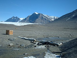
| Description | December 12, 2001 photo of the USGS streamflow-gaging station at Huey Creek, McMurdo Dry Valleys, Antarctica. |
| Date | |
| Source | USGS Surface Water Photo Gallery, item 10 10 |
| Author | Jerrod Wheeler (submitted to USGS by Kirk Miller, Wyoming) |
| Permission (Reusing this file) |
Public Domain |
Licensing edit
This image is in the public domain in the United States because it only contains materials that originally came from the United States Geological Survey, an agency of the United States Department of the Interior. For more information, see the official USGS copyright policy.
|
Original upload log edit
The original description page was here. All following user names refer to en.wikipedia.
- 2008-09-04 23:25 Suntag 1600×1200× (370489 bytes)
File history
Click on a date/time to view the file as it appeared at that time.
| Date/Time | Thumbnail | Dimensions | User | Comment | |
|---|---|---|---|---|---|
| current | 11:36, 18 January 2010 | | 1,600 × 1,200 (362 KB) | 4ing (talk | contribs) | {{Information |Description={{en|December 12, 2001 photo of the en:USGS streamflow-gaging [http://metacat.lternet.edu/knb/metacat?action=read&qformat=mcm&docid=knb-lter-mcm.9029 station] at en:Huey Creek, [[:en:McMurdo Dry |
You cannot overwrite this file.
File usage on Commons
The following 2 pages use this file:
File usage on other wikis
The following other wikis use this file:
- Usage on ar.wikipedia.org
- Usage on ceb.wikipedia.org
- Usage on cs.wikipedia.org
- Usage on de.wikipedia.org
- Usage on en.wikipedia.org
- Stream gauge
- Lake Hoare
- McKelvey Valley
- Shaw Trough
- Prospect Mesa
- Taylor Valley
- Williams Pond
- Andersen Creek
- Anderson Scarp
- Bohner Stream
- Mount Booth
- Butler Summit
- Canada Peak
- Cleft Ledge
- Clow Island
- Watanuki Pond
- Stepping Stone Pond
- Lake Joyce
- Kurasawa Pond
- Murray Pond
- Friis Hills
- Gupwell Pond
- Don Quixote Pond
- Doolittle Bluff
- Doran Stream
- Plane Table Glacier
- Penhale Peak
- Gurkha Peak
- Hall Bluff
- Lizotte Creek
- Linnaeus Terrace
- McKay Creek
- Mount McLennan (Victoria Land)
- Mount Hercules
- Matsumoto Pond
- Sanders Nunatak
- Mount Torii
- Lyons Creek (Antarctica)
- Vincent Creek
- Template:McMurdoDryValleys-geo-stub
- Usage on es.wikipedia.org
- Usage on lv.wikipedia.org
- Usage on nl.wikipedia.org
- Usage on nn.wikipedia.org
View more global usage of this file.