File:Hull Docks West.jpg
Size of this preview: 800 × 425 pixels. Other resolutions: 320 × 170 pixels | 640 × 340 pixels | 1,024 × 544 pixels | 1,280 × 680 pixels | 2,673 × 1,419 pixels.
Original file (2,673 × 1,419 pixels, file size: 268 KB, MIME type: image/jpeg)
Captions
Captions
Add a one-line explanation of what this file represents
Summary edit
| Description |
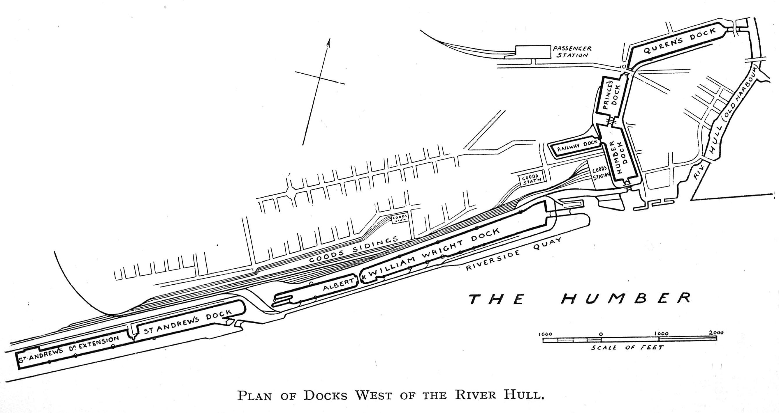
English: Plan showing Hull town docks west of the river Hull (c.1912) - docks at their maximum extent west of the river, Paragon station ("passenger station"), and three goods stations shown, each operated by a sepated company, easternmost is NER station (on site of the original Hull and Selby station), western most is H&BR station (Neptune street), middle one was originally a Manchester, Sheffields and Lincolnshire (MS&LR) goods station |
| Date | |
| Source |
"The story of the East Riding of Yorkshire" (1912), Author: Browne, Horace B. (Horace Baker) https://archive.org/details/storyofeastridin00browuoft https://archive.org/stream/storyofeastridin00browuoft#page/258/mode/2up (pages 258 and 259) |
| Author | unknown, book author given in source |
Licensing edit
This media file is in the public domain in the United States. This applies to U.S. works where the copyright has expired, often because its first publication occurred prior to January 1, 1929, and if not then due to lack of notice or renewal. See this page for further explanation.
|
 | |
 |
This image might not be in the public domain outside of the United States; this especially applies in the countries and areas that do not apply the rule of the shorter term for US works, such as Canada, Mainland China (not Hong Kong or Macao), Germany, Mexico, and Switzerland. The creator and year of publication are essential information and must be provided. See Wikipedia:Public domain and Wikipedia:Copyrights for more details.
|
File history
Click on a date/time to view the file as it appeared at that time.
| Date/Time | Thumbnail | Dimensions | User | Comment | |
|---|---|---|---|---|---|
| current | 06:53, 27 May 2012 | | 2,673 × 1,419 (268 KB) | Oranjblud (talk | contribs) |
You cannot overwrite this file.
File usage on Commons
The following page uses this file: