File:Huntly station geograph-3537622-by-Ben-Brooksbank.jpg

Size of this preview: 800 × 532 pixels. Other resolutions: 320 × 213 pixels | 640 × 425 pixels | 1,024 × 681 pixels | 1,280 × 851 pixels | 2,391 × 1,589 pixels.
Original file (2,391 × 1,589 pixels, file size: 3.95 MB, MIME type: image/jpeg)
Captions
Captions
Add a one-line explanation of what this file represents
Summary
edit
| Description |
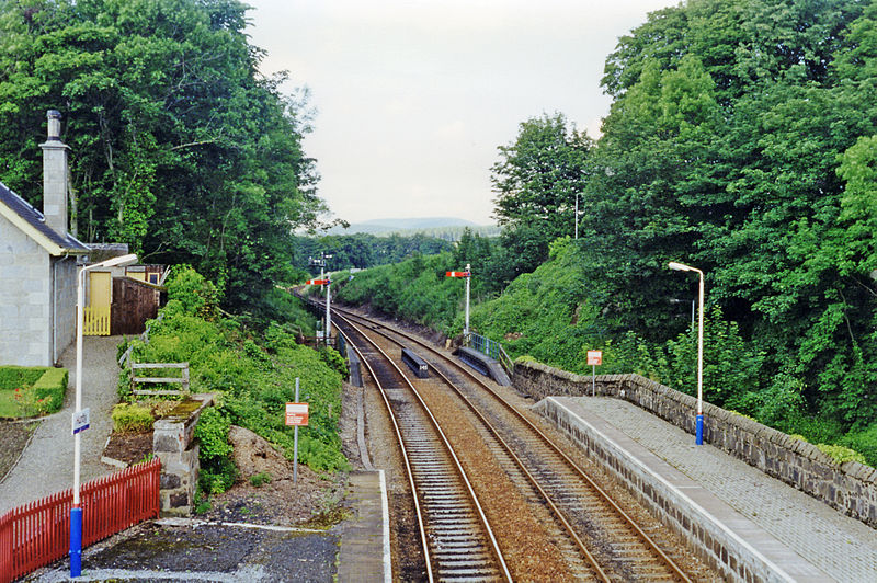
English: Huntly station, 1997. View northward, towards Keith, then Elgin and Inverness by the ex-Highland Railway route. This station is on the surviving section of the ex-GNSR main line from Aberdeen, which used to go until 1968 to Elgin also via Cairnie Junction and Buckie. |
| Date | |
| Source | From geograph.org.uk |
| Author | Ben Brooksbank |
| Permission (Reusing this file) |
Creative Commons Attribution Share-alike license 2.0 |
| Attribution (required by the license) | Ben Brooksbank / Huntley station, 1997 / |
| Camera location | | View this and other nearby images on: OpenStreetMap |
|---|
Licensing
edit

|
This image was taken from the Geograph project collection. See this photograph's page on the Geograph website for the photographer's contact details. The copyright on this image is owned by Ben Brooksbank and is licensed for reuse under the Creative Commons Attribution-ShareAlike 2.0 license.
|
This file is licensed under the Creative Commons Attribution-Share Alike 2.0 Generic license.
Attribution: Ben Brooksbank
- You are free:
- to share – to copy, distribute and transmit the work
- to remix – to adapt the work
- Under the following conditions:
- attribution – You must give appropriate credit, provide a link to the license, and indicate if changes were made. You may do so in any reasonable manner, but not in any way that suggests the licensor endorses you or your use.
- share alike – If you remix, transform, or build upon the material, you must distribute your contributions under the same or compatible license as the original.
File history
Click on a date/time to view the file as it appeared at that time.
| Date/Time | Thumbnail | Dimensions | User | Comment | |
|---|---|---|---|---|---|
| current | 07:15, 3 August 2013 | | 2,391 × 1,589 (3.95 MB) | Chevin (talk | contribs) | == {{int:filedesc}} == {{Information |Description={{en|1='''Huntly station, 1997.'''<br/> View northward, towards Keith, then Elgin and Inverness by the ex-Highland Railway route. This station is on the surviving section of the ex-GNSR main line from A... |
You cannot overwrite this file.
File usage on Commons
The following page uses this file:
File usage on other wikis
The following other wikis use this file:
- Usage on en.wikipedia.org
- Insch railway station
- Portlethen railway station
- Abbey of Deer Platform railway station
- Lethenty railway station
- Port Elphinstone railway station
- Alford railway station
- Whitehouse railway station (Scotland)
- Tillyfourie railway station
- Monymusk railway station
- Kemnay railway station
- Kinaldie railway station
- Parkhill railway station
- Newmachar railway station
- Udny railway station
- Logierieve railway station
- Esslemont railway station
- Mintlaw railway station
- Longside railway station
- Newseat Halt railway station
- Inverugie railway station
- Peterhead railway station
- Peterhead Docks railway station
- Strichen railway station
- Brucklay railway station
- Mormond Halt railway station
- Lonmay railway station
- Rathen railway station
- Philorth Halt railway station
- Fraserburgh railway station
- Ellon railway station
- Arnage railway station
- Auchnagatt railway station
- Auchmacoy railway station
- Pitlurg railway station
- Hatton railway station (Aberdeenshire)
- Cruden Bay railway station
- Longhaven railway station
- Boddam railway station
- Rothienorman railway station
- Plaidy railway station
- King Edward railway station
- Banff Bridge railway station
- Macduff railway station
- Pitcaple railway station
- Oyne railway station
- Fingask railway station
- Ordens railway station
- Ladysbridge railway station
- Newtonhill railway station
- Bankhead railway station (Aberdeen)
View more global usage of this file.