File:Hurd-Peninsula-location-map.png

Size of this preview: 800 × 548 pixels. Other resolutions: 320 × 219 pixels | 640 × 439 pixels | 1,024 × 702 pixels | 1,280 × 877 pixels | 1,669 × 1,144 pixels.
Original file (1,669 × 1,144 pixels, file size: 144 KB, MIME type: image/png)
Captions
Captions
Add a one-line explanation of what this file represents
Summary edit
| Description |
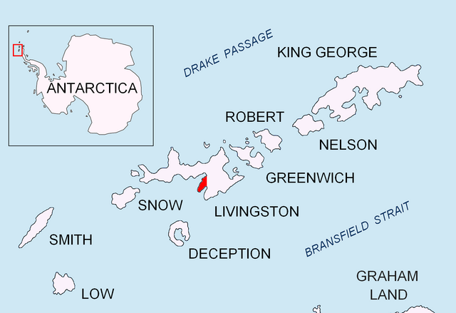
English: Location of Hurd Peninsula on Livingston Island in the South Shetland Islands. |
| Date | |
| Source | Own work |
| Author | Apcbg |
Licensing edit
I, the copyright holder of this work, hereby publish it under the following licenses:
This file is licensed under the Creative Commons Attribution-Share Alike 3.0 Unported license.
- You are free:
- to share – to copy, distribute and transmit the work
- to remix – to adapt the work
- Under the following conditions:
- attribution – You must give appropriate credit, provide a link to the license, and indicate if changes were made. You may do so in any reasonable manner, but not in any way that suggests the licensor endorses you or your use.
- share alike – If you remix, transform, or build upon the material, you must distribute your contributions under the same or compatible license as the original.

|
Permission is granted to copy, distribute and/or modify this document under the terms of the GNU Free Documentation License, Version 1.2 or any later version published by the Free Software Foundation; with no Invariant Sections, no Front-Cover Texts, and no Back-Cover Texts. A copy of the license is included in the section entitled GNU Free Documentation License. |
You may select the license of your choice.
File history
Click on a date/time to view the file as it appeared at that time.
| Date/Time | Thumbnail | Dimensions | User | Comment | |
|---|---|---|---|---|---|
| current | 21:11, 1 November 2012 | | 1,669 × 1,144 (144 KB) | JeffyP (talk | contribs) | I make things smaller. |
| 06:51, 5 September 2010 |  | 1,669 × 1,144 (151 KB) | Apcbg (talk | contribs) | {{Information |Description={{en|1=Location of Hurd Peninsula on Livingston Island in the South Shetland Islands.}} |Source={{own}} |Author=Apcbg |Date=2010-09-05 |Permission= |other_versions= }} Category:Maps of Antarctica |
You cannot overwrite this file.
File usage on Commons
The following page uses this file:
File usage on other wikis
The following other wikis use this file:
- Usage on ar.wikipedia.org
- Usage on bg.wikipedia.org
- Usage on ca.wikipedia.org
- Usage on cs.wikipedia.org
- Usage on de.wikipedia.org
- Usage on en.wikipedia.org
- Atlantic Club Ridge
- Bulgarian Beach
- Charrúa Gap
- Hesperides Hill
- Krum Rock
- Rezovski Creek
- Sea Lion Tarn
- Sinemorets Hill
- Spanish Knoll
- Spanish Point (Antarctica)
- Vergilov Rocks
- Belozem Hill
- Grand Lagoon
- Castro Peak
- Ballester Point
- Castellvi Peak
- Hurd Peninsula
- Juan Carlos I Antarctic Base
- Hespérides Point
- Napier Peak
- Johnsons Dock
- Charrúa Ridge
- Johnsons Glacier
- Contell Glacier
- Castillo Nunatak
- Miers Bluff
- Mirador Hill
- Moores Peak
- MacGregor Peaks
- Polish Bluff
- Henry Bluff
- Salisbury Bluff
- Sally Rocks
- Española Cove
- Argentina Cove
- Las Palmas Cove
- Mount Reina Sofía
- Hurd Ice Cap
- Svelten Peak
- Buena Nueva Cove
- Glaciar Rocoso Cove
- Pesyakov Hill
- Las Palmas Glacier
View more global usage of this file.