File:Hurd Deep from cropped Admiralty Chart No 2649 English Channel Western Portion Published 1955.jpg

Size of this preview: 800 × 452 pixels. Other resolutions: 320 × 181 pixels | 640 × 362 pixels | 1,024 × 579 pixels | 1,280 × 724 pixels | 3,119 × 1,764 pixels.
Original file (3,119 × 1,764 pixels, file size: 428 KB, MIME type: image/jpeg)
Captions
Captions
Add a one-line explanation of what this file represents
Summary
edit| Description |
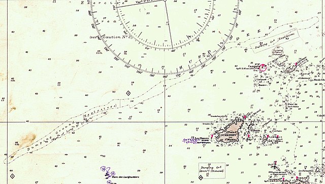
English: Nautical chart covering the area from the Isles of Scilly to Portsmouth and Ile d'Ouessant to Barfleur to a scale of 1/500,000. Printed corrections to 1964, with later corrections added by hand. Not current - not to be used for navigation!
Français : Carte marine ancienne (1955) couvrant la zone des îles Scilly à Portsmouth et de l'île d'Ouessant à Barfleur ; échelle 1/500 000. Corrections imprimées jusqu'en 1964, avec des corrections ultérieures ajoutées à la main. 5 zones de dépôts de munitions y figurent, dont la fosse des Casquets (à ne pas utiliser pour la navigation) ! |
| Date | |
| Source | UK Admiralty Chart No 2649 |
| Author | K St B Collins |
| Other versions |

Licensing
edit
This work created by the United Kingdom Government is in the public domain.
This is because it is one of the following:
HMSO has declared that the expiry of Crown Copyrights applies worldwide (ref: HMSO Email Reply)
|
 |
File history
Click on a date/time to view the file as it appeared at that time.
| Date/Time | Thumbnail | Dimensions | User | Comment | |
|---|---|---|---|---|---|
| current | 06:24, 15 August 2019 | | 3,119 × 1,764 (428 KB) | Djm-leighpark (talk | contribs) | File:Admiralty Chart No 2649 English Channel Western Portion Published 1955.jpg cropped 70 % horizontally, 76 % vertically using CropTool with lossless mode. |
You cannot overwrite this file.
File usage on Commons
The following page uses this file:
File usage on other wikis
The following other wikis use this file:
- Usage on en.wikipedia.org