File:Hurricane Carlos in 3D.jpg

Original file (849 × 849 pixels, file size: 133 KB, MIME type: image/jpeg)
Captions
Captions
Summary edit
| Description |
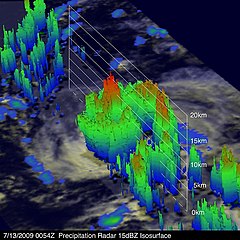
English: NASA Sees Carlos Power Back Up to Hurricane Status in 3-D
TRMM 3-D image shows thunderstorm tops reaching about 9.3 miles high in the eastern side of the storm. Credit: NASA/SSAI, Hal Pierce Carlos became a hurricane for about 24 hours over the previous weekend, then powered down to a tropical storm and now atmospheric conditions have enabled him to power back into a hurricane in the Eastern Pacific Ocean. NASA's Tropical Rainfall Measuring Mission (TRMM) satellite has been capturing images of Carlos since it was born as tropical depression #4E last week. Scientists at NASA can use TRMM data to provide forecasters a 3-D look at the storm's cloud heights and rainfall, which is extremely helpful in forecasting. "One of the interesting capabilities of the TRMM satellite is its ability to see through clouds with its Precipitation Radar (PR) and reveal the 3-D structure within storms such as Hurricane Carlos," said Hal Pierce, on the TRMM mission team in the Mesoscale Atmospheric Processes Branch at NASA's Goddard Space Flight Center, Greenbelt, Md. Pierce created a 3-D image of Carlos. He used data captured on July 13 when TRMM also got a "top down" view of the storm's rainfall, and created a 3-D image that shows thunderstorm tops reaching to almost 15 kilometers (9.3 miles) high in the eastern side of the storm. On Tuesday, July 14, 2009 at 6 a.m. EDT (3 a.m. PDT), Carlos had regained hurricane status as a Category One storm on the Saffir-Simpson Scale with maximum sustained winds near 75 mph. Carlos was located near latitude 9.7 north and longitude 127.2 west. That's about 1,465 miles or southwest of the southern tip of Baja California. Carlos continues to move west near 9 mph and has a minimum central pressure of 987 millibars. Carlos is predicted to move to within about 720 miles southeast of the Hawaiian Islands on Saturday, July 18, 2009. Text credit: Rob Gutro, NASA's Goddard Space Flight Center |
| Date | |
| Source | https://www.flickr.com/photos/24662369@N07/3723376879/ |
| Author | NASA Goddard Photo and Video |
Licensing edit
- You are free:
- to share – to copy, distribute and transmit the work
- to remix – to adapt the work
- Under the following conditions:
- attribution – You must give appropriate credit, provide a link to the license, and indicate if changes were made. You may do so in any reasonable manner, but not in any way that suggests the licensor endorses you or your use.
| This image was originally posted to Flickr by NASA Goddard Photo and Video at https://flickr.com/photos/24662369@N07/3723376879. It was reviewed on 15 March 2020 by FlickreviewR 2 and was confirmed to be licensed under the terms of the cc-by-2.0. |

|
This media file is uncategorized.
Please help improve this media file by adding it to one or more categories, so it may be associated with related media files (how?), and so that it can be more easily found.
Please notify the uploader with {{subst:Please link images|File:Hurricane Carlos in 3D.jpg}} ~~~~ |
File history
Click on a date/time to view the file as it appeared at that time.
| Date/Time | Thumbnail | Dimensions | User | Comment | |
|---|---|---|---|---|---|
| current | 00:39, 15 March 2020 | | 849 × 849 (133 KB) | Killarnee (talk | contribs) | Uploaded a work by NASA Goddard Photo and Video from https://www.flickr.com/photos/24662369@N07/3723376879/ with UploadWizard |
You cannot overwrite this file.
File usage on Commons
The following page uses this file: