File:Hurricane Florence (MODIS 2018-09-15).jpg

Original file (8,706 × 7,584 pixels, file size: 7.77 MB, MIME type: image/jpeg)
Captions
Captions
Summary
edit.jpg&action=edit§ion=1)
| Description |
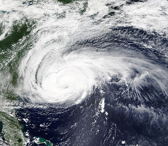
English: On September 13, 2018, the center of Hurricane Florence was poised to strike the North Carolina coast while heavy winds and pouring rain had already reached well inland when NASA’s Terra satellite flew over the storm. The Moderate Resolution Imaging Spectroradiometer (MODIS) acquired a true-color image of the huge, strong, rain-filled storm on that same day.
At the time this image was captured, interaction with the coastline was beginning to create adverse conditions that affected the storm, causing it to elongate – and to lose some power. As the slow-moving hurricane crept towards the coastline, maximum sustained winds dropped from 140 mph (225 km/h), which it held from September 10 – 11, by about 50 mph (80.5 km/h) before landfall. While wind speed is not the only factor in damage from a hurricane – rainfall, storm surge, and speed of forward movement are all also important – the destructive power of the winds in a major hurricane (Category 3 or greater) can’t be underestimated. The drop from a Category 4 storm to a Category 1 at landfall changed the anticipated wind damage from “catastrophic damage will occur” to “very dangerous winds will produce some damage”. Hurricane Florence made landfall near Wrightsville Beach, North Carolina at 7:15 AM EDT (1115 UTC) on September 14 with estimated maximum winds of 90 mph (150 km/h), and a minimum central pressure estimate of 958 millibars. Winds gusts topping 105 mph (169 km/h) were reported in the Outer Banks of North Carolina. As of 11:00 p.m. EDT on September 14, the National Hurricane Center (NHC) reported that Florence was downgraded to a tropical storm, with maximum sustained winds of 65 mph (100 km/h). The center of the system was located about 15 mi (20 km) west northwest of Myrtle Beach, South Carolina and 45 mi (70 km) southeast of Florence, South Carolina. According to CNN, some areas of the Carolinas have already reported 20 inches (508 mm) of rain – with more to come as the slow-moving storm continues to crawl inland. There are reports of widespread flooding, power outage to more than 800,000 people in North and South Carolina, and hundreds of rescues and on-going attempts to rescue people who refused follow evacuation orders. |
||
| Date | Taken on 13 September 2018 | ||
| Source |
Hurricane Florence (direct link)
|
||
| Author | MODIS Land Rapid Response Team, NASA GSFC |
| This media is a product of the Terra mission Credit and attribution belongs to the mission team, if not already specified in the "author" row |
Licensing
edit.jpg&action=edit§ion=2)
| This file is in the public domain in the United States because it was solely created by NASA. NASA copyright policy states that "NASA material is not protected by copyright unless noted". (See Template:PD-USGov, NASA copyright policy page or JPL Image Use Policy.) | ||
 |
Warnings:
|
File history
Click on a date/time to view the file as it appeared at that time.
| Date/Time | Thumbnail | Dimensions | User | Comment | |
|---|---|---|---|---|---|
| current | 01:31, 17 February 2024 | | 8,706 × 7,584 (7.77 MB) | OptimusPrimeBot (talk | contribs) | #Spacemedia - Upload of http://modis.gsfc.nasa.gov/gallery/images/image09152018_250m.jpg via Commons:Spacemedia |
You cannot overwrite this file.
File usage on Commons
There are no pages that use this file.
.jpg&oldid=909382567)