File:Hurricane Humberto (MODIS 2019-09-17).jpg

Original file (7,249 × 6,014 pixels, file size: 11.68 MB, MIME type: image/jpeg)
Captions
Captions
Summary
edit.jpg&action=edit§ion=1)
| Description |
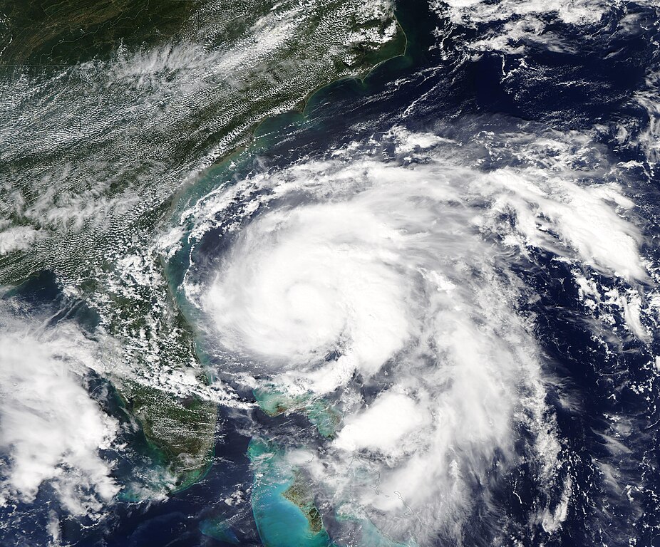
English: On September 12, 2019, the National Hurricane Center (NHC) issued an advisory for the potential formation of a tropical storm in the Atlantic Ocean centered about 235 mi (380 km) southeast of Great Abaco Island and about 310 mi (500 km) southeast of Freeport, Grand Bahama Island. The government of the Bahamas issued a Tropical Storm Warning for several of the islands, including the areas which had been devastated by Category 5 Hurricane Dorian which struck the Abacos on September 1, then continued to pummel the eastern end of Grand Bahama for most of September 2.
The system slowly meandered over many of the islands of the Bahamas carrying maximum sustained winds of about 30 mph (45 km/h) and bringing rain before becoming a depression on the afternoon of September 13. Wind speeds picked up quickly, and the system was named Tropical Storm Humberto that evening. On September 14, Humberto moved east of Great Abaco Island, with most of the strongest squalls staying to the north and east of center. The storm continued to move north-northwestward, sparing the hardest hit areas of the Bahamas. After moving north of the Bahamas, Humberto continued to strengthen. On September 15, the NHC advised that Humberto had become a hurricane in the waters about 785 miles (1,260 km) west of Bermuda and well away from the Bahamas. Maximum sustained winds had reached 75 mph (120 km/h). As of 5:00 p.m. EDT (2100 UTC) on September 16, Hurricane Humberto was continuing to strengthen, carrying maximum sustained winds of 90 mph (150 km/h). It was located about 670 miles (1,080 km) west of Bermuda and was moving to the east-northeast at 7 mph (11 km/h). The NHC expects additional strengthening during the next 48 hours, with Humberto becoming a major hurricane at the end of that time. Hurricane-force winds extend outward for up to 30 miles (45 km) from the center and tropical-storm-force winds extend outward up to 150 miles (240 km) from the center. Bermuda has issued tropical storm warnings and will likely be impacted by wind and rain, although the storm’s center is forecast to miss Bermuda. The Moderate Resolution Imaging Spectroradiometer (MODIS) on board NASA’s Aqua satellite acquired a true-color image of Hurricane Humberto on September 15, 2019. The storm’s cloud-filled center sits north east of the Bahamas, while convective bands carrying rain and thunderstorms shroud some of the islands of the Bahamas and come close to the shore of the southeastern United States. |
||
| Date | Taken on 15 September 2019 | ||
| Source |
Hurricane Humberto (direct link)
|
||
| Author | MODIS Land Rapid Response Team, NASA GSFC |
| This media is a product of the Aqua mission Credit and attribution belongs to the mission team, if not already specified in the "author" row |
Licensing
edit.jpg&action=edit§ion=2)
| This file is in the public domain in the United States because it was solely created by NASA. NASA copyright policy states that "NASA material is not protected by copyright unless noted". (See Template:PD-USGov, NASA copyright policy page or JPL Image Use Policy.) | ||
 |
Warnings:
|
File history
Click on a date/time to view the file as it appeared at that time.
| Date/Time | Thumbnail | Dimensions | User | Comment | |
|---|---|---|---|---|---|
| current | 03:02, 17 February 2024 | | 7,249 × 6,014 (11.68 MB) | OptimusPrimeBot (talk | contribs) | #Spacemedia - Upload of http://modis.gsfc.nasa.gov/gallery/images/image09172019_250m.jpg via Commons:Spacemedia |
You cannot overwrite this file.
File usage on Commons
There are no pages that use this file.
.jpg&oldid=852753983)