File:Hurricane Ophelia 2005 enlarged map.png

Size of this preview: 623 × 599 pixels. Other resolutions: 249 × 240 pixels | 499 × 480 pixels | 798 × 768 pixels | 1,064 × 1,024 pixels | 1,501 × 1,444 pixels.
Original file (1,501 × 1,444 pixels, file size: 1.8 MB, MIME type: image/png)
Captions
Captions
Add a one-line explanation of what this file represents
Summary edit
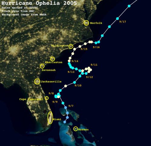
| Description |
|
||||||||||||||
| Source | Created using Wikipedia:WikiProject Tropical cyclones/Tracks. The background image is from NASA. Tracking data from the National Hurricane Center.[1] | ||||||||||||||
| Author | See file upload history for details. | ||||||||||||||
| I, the copyright holder of this work, release this work into the public domain. This applies worldwide. In some countries this may not be legally possible; if so: I grant anyone the right to use this work for any purpose, without any conditions, unless such conditions are required by law. |
File history
Click on a date/time to view the file as it appeared at that time.
| Date/Time | Thumbnail | Dimensions | User | Comment | |
|---|---|---|---|---|---|
| current | 21:10, 31 October 2021 | | 1,501 × 1,444 (1.8 MB) | Cyclonebiskit (talk | contribs) | {{Hurricane auto track map|type=Hurricane|name=Ophelia (2005)|source=NHC}} |
You cannot overwrite this file.
File usage on Commons
There are no pages that use this file.