File:Hutton-le-Hole - geograph.org.uk - 1716001.jpg
No higher resolution available.
Hutton-le-Hole_-_geograph.org.uk_-_1716001.jpg (640 × 360 pixels, file size: 106 KB, MIME type: image/jpeg)
Captions
Captions
Add a one-line explanation of what this file represents
Summary
edit
| Description |
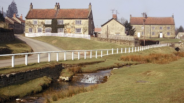
English: Hutton-le-Hole
This photograph shows the southern end of Hutton le Hole. The stream flowing across the bottom of the picture is Hutton Beck. The word 'beck' is derived from the Old Norse word, bekkr, meaning stream. The date given is the processing date on the slide and therefore could have been taken several weeks earlier. - - - Compare the above photograph with one taken by Andy Beecroft 30 years later in 2003, 14620. |
| Date | |
| Source | From geograph.org.uk |
| Author | Alan Walker |
| Attribution (required by the license) | Alan Walker / Hutton-le-Hole / |
| Camera location | | View this and other nearby images on: OpenStreetMap |
|---|
_heading:315.00&language=en)
| Object location | | View this and other nearby images on: OpenStreetMap |
|---|
_heading:315.00&language=en)
Licensing
edit

|
This image was taken from the Geograph project collection. See this photograph's page on the Geograph website for the photographer's contact details. The copyright on this image is owned by Alan Walker and is licensed for reuse under the Creative Commons Attribution-ShareAlike 2.0 license.
|
This file is licensed under the Creative Commons Attribution-Share Alike 2.0 Generic license.
Attribution: Alan Walker
- You are free:
- to share – to copy, distribute and transmit the work
- to remix – to adapt the work
- Under the following conditions:
- attribution – You must give appropriate credit, provide a link to the license, and indicate if changes were made. You may do so in any reasonable manner, but not in any way that suggests the licensor endorses you or your use.
- share alike – If you remix, transform, or build upon the material, you must distribute your contributions under the same or compatible license as the original.
File history
Click on a date/time to view the file as it appeared at that time.
| Date/Time | Thumbnail | Dimensions | User | Comment | |
|---|---|---|---|---|---|
| current | 08:30, 5 March 2011 | | 640 × 360 (106 KB) | GeographBot (talk | contribs) | == {{int:filedesc}} == {{Information |description={{en|1=Hutton-le-Hole This photograph shows the southern end of Hutton le Hole. The stream flowing across the bottom of the picture is Hutton Beck. The word beck is derived from the Old Norse wo |
You cannot overwrite this file.
File usage on Commons
There are no pages that use this file.