File:Hvalbiartunnil and Kolavegur Hvalba Faroe Islands.JPG

Size of this preview: 800 × 600 pixels. Other resolutions: 320 × 240 pixels | 640 × 480 pixels | 1,024 × 768 pixels | 1,280 × 960 pixels | 2,560 × 1,920 pixels | 3,648 × 2,736 pixels.
Original file (3,648 × 2,736 pixels, file size: 2.11 MB, MIME type: image/jpeg)
Captions
Captions
Add a one-line explanation of what this file represents
Summary
edit
| Description |
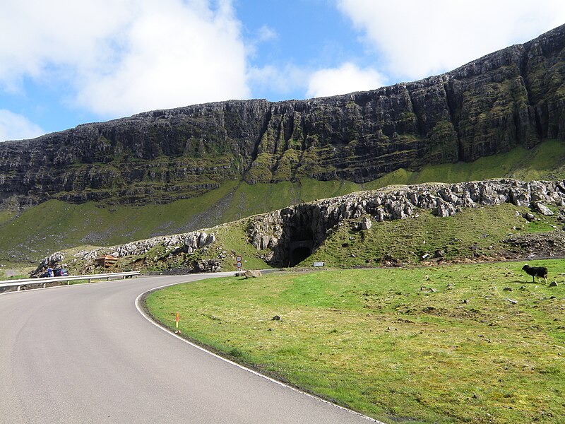
English: Hvalbiartunnilin is the oldest tunnel in the Faroe Islands. It connects Hvalba with Trongisvágur and the rest of the island Suðuroy. The tunnel was built in 1963 and is still in use (2011). The tunnel has only one lane and meeting areas to one side, it is marked with an M sign where these areas are. The tunnel is located quite far away from the village Hvalba, up in the valley on a mountain side where there are coal mines. The coal is in around the same level as the tunnel is.
Føroyskt: Hvalbiartunnilin er elsti tunnil í Føroyum. Hann var bygdur í 1963 og er enn í brúk og einasta farleið ið fólk úr Hvalba og Sandvík mugu ferðast eftir, tá tey skulu til arbeiðis á Tvøroyri ella eitt hvørt ørindi til onnur støð á oynni sum eru sunnanfyri Hvalba, ella tá tey skulu av oynni, so er einasta farleið úr Hvalba gjøgnum henda tunnilin. Vegurin Hvalbiarmeðna eitur Kolavegurin. Navnið kemur av at har eru kolanám við tunnilin. Hvalbingar hava í nógv ár ynskt nýggja tunnil, sum skal vera á sama støði sum aðrir nýmótans tunlar og hann skal vera nógv longri niðri, so tey sleppa undan at koyra niðan eftir Kolavegnum í hálku um veturin. Tunnilin er einsporaður við møtiplássum í tí eini síðuni. Har er onki ljós inni í tunlinum. |
| Date | |
| Source | Own work |
| Author | Eileen Sandá |
| Camera location | | View this and other nearby images on: OpenStreetMap |
|---|
Licensing
edit
I, the copyright holder of this work, hereby publish it under the following licenses:
This file is licensed under the Creative Commons Attribution-Share Alike 3.0 Unported license.
- You are free:
- to share – to copy, distribute and transmit the work
- to remix – to adapt the work
- Under the following conditions:
- attribution – You must give appropriate credit, provide a link to the license, and indicate if changes were made. You may do so in any reasonable manner, but not in any way that suggests the licensor endorses you or your use.
- share alike – If you remix, transform, or build upon the material, you must distribute your contributions under the same or compatible license as the original.

|
Permission is granted to copy, distribute and/or modify this document under the terms of the GNU Free Documentation License, Version 1.2 or any later version published by the Free Software Foundation; with no Invariant Sections, no Front-Cover Texts, and no Back-Cover Texts. A copy of the license is included in the section entitled GNU Free Documentation License. |
You may select the license of your choice.
File history
Click on a date/time to view the file as it appeared at that time.
| Date/Time | Thumbnail | Dimensions | User | Comment | |
|---|---|---|---|---|---|
| current | 16:09, 15 August 2011 | | 3,648 × 2,736 (2.11 MB) | EileenSanda (talk | contribs) | {{Information |Description ={{en|1=Hvalbiartunnilin is the oldest tunnel in the Faroe Islands. It connects Hvalba with Trongisvágur and the rest of the island Suðuroy. The tunnel was built in 1963 and is still in use (2011). The tunnel has only one l |
You cannot overwrite this file.
File usage on Commons
The following 2 pages use this file:
File usage on other wikis
The following other wikis use this file:
- Usage on ca.wikipedia.org
- Usage on es.wikipedia.org
- Usage on fo.wikipedia.org
- Usage on nl.wikipedia.org
- Usage on no.wikipedia.org
- Usage on www.wikidata.org