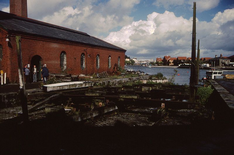
File:Hydraulic engine house & slipway, Underfall Yard, Bristol 10.9.1994 Scans005 (10876867295).jpg

Original file (2,294 × 1,528 pixels, file size: 563 KB, MIME type: image/jpeg)
Captions
Captions
Summary edit
| DescriptionHydraulic engine house & slipway, Underfall Yard, Bristol 10.9.1994 Scans005 (10876867295).jpg |
The Underfall Yard is a historic boatyard on Spike Island serving Bristol Harbour, the harbour in the city of Bristol, England. Underfall Yard was commonly referred to as "The Underfalls" and takes its name from the underfall sluices. The original construction (designed by William Jessop) was in the early 19th century with revisions by Isambard Kingdom Brunel in the 1830s. Following restoration in the 1990s, this Victorian work yard is now a Scheduled Monument that includes several listed buildings. The harbour and its equipment are still actively maintained, and host a cooperative of boat builders. The octagonal brick and terracotta chimney of the engine house dates from 1888, and is grade II* listed, as is the hydraulic engine house itself. It replaced the original pumping house which is now The Pump House public house. It is built of red brick with a slate roof and originally contained two steam engines. These were replaced in 1907 by the current electric machines from Fullerton, Hodgart and Barclay of Paisley. It powers the docks hydraulic system of cranes, bridges and locks. The original slipway was built by John Ward Girdlestone in 1890 which had replaced a predecessor built in the 1850s by boatbuilders Ross and Sage. It used a system in which the ship is floated onto the cradle and secured. The cradle is then drawn out of the water with a steam-driven winch. The device was a low-cost alternative to dry docks for maintenance and repair work. This became known as the Patent slipway or 'Heave-up Slip' and was patented in 1819 by shipbuilder Thomas Morton of Leith in Scotland. [Source: en.wikipedia.org/wiki/Underfall_Yard] |
| Date | |
| Source | Hydraulic engine house & slipway, Underfall Yard, Bristol 10.9.1994 Scans005 |
| Author | Gillett's Crossing from Bristol, United Kingdom |
| Camera location | 51° 26′ 48.26″ N, 2° 37′ 05.79″ W | View this and other nearby images on: OpenStreetMap |
|---|
Licensing edit
- You are free:
- to share – to copy, distribute and transmit the work
- to remix – to adapt the work
- Under the following conditions:
- attribution – You must give appropriate credit, provide a link to the license, and indicate if changes were made. You may do so in any reasonable manner, but not in any way that suggests the licensor endorses you or your use.
| This image was originally posted to Flickr by Gillett's Crossing at https://www.flickr.com/photos/83763404@N07/10876867295. It was reviewed on 3 April 2014 by FlickreviewR and was confirmed to be licensed under the terms of the cc-by-2.0. |
3 April 2014
File history
Click on a date/time to view the file as it appeared at that time.
| Date/Time | Thumbnail | Dimensions | User | Comment | |
|---|---|---|---|---|---|
| current | 22:39, 3 April 2014 |  | 2,294 × 1,528 (563 KB) | Ultra7 (talk | contribs) | Transferred from Flickr |
You cannot overwrite this file.
File usage on Commons
The following page uses this file:
Metadata
This file contains additional information such as Exif metadata which may have been added by the digital camera, scanner, or software program used to create or digitize it. If the file has been modified from its original state, some details such as the timestamp may not fully reflect those of the original file. The timestamp is only as accurate as the clock in the camera, and it may be completely wrong.
| Date and time of data generation | 23:26, 10 September 1994 |
|---|---|
| Orientation | Normal |
| Software used | Microsoft Windows Photo Gallery 6.0.6001.18000 |
| File change date and time | 23:39, 10 November 2013 |
| Date and time of digitizing | 23:26, 10 September 1994 |
| DateTimeOriginal subseconds | 90 |
| DateTimeDigitized subseconds | 90 |
| Unique image ID | 7D5638D053BB460CAA5C0E074FC1DF0F |
| Keywords |
|