File:I-69 (IN) map.png

Size of this preview: 800 × 466 pixels. Other resolutions: 320 × 187 pixels | 640 × 373 pixels | 1,024 × 597 pixels | 1,280 × 746 pixels | 2,000 × 1,166 pixels.
Original file (2,000 × 1,166 pixels, file size: 70 KB, MIME type: image/png)
Captions
Captions
Add a one-line explanation of what this file represents
Summary edit
_map.png&action=edit§ion=1)
| Description |
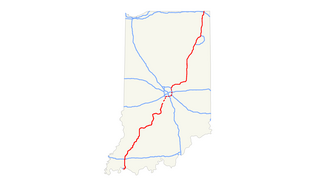
English: Interstate 69 in Indiana |
| Date | |
| Source | Own work |
| Author | Rhatsa26X |
Licensing edit
_map.png&action=edit§ion=2)
I, the copyright holder of this work, hereby publish it under the following license:
This file is licensed under the Creative Commons Attribution-Share Alike 3.0 Unported license.
- You are free:
- to share – to copy, distribute and transmit the work
- to remix – to adapt the work
- Under the following conditions:
- attribution – You must give appropriate credit, provide a link to the license, and indicate if changes were made. You may do so in any reasonable manner, but not in any way that suggests the licensor endorses you or your use.
- share alike – If you remix, transform, or build upon the material, you must distribute your contributions under the same or compatible license as the original.
File history
Click on a date/time to view the file as it appeared at that time.
| Date/Time | Thumbnail | Dimensions | User | Comment | |
|---|---|---|---|---|---|
| current | 07:28, 11 June 2019 | | 2,000 × 1,166 (70 KB) | OrdinaryScarlett (talk | contribs) | Updated line to reflect extension to Martinsville. |
| 19:05, 11 November 2015 |  | 2,000 × 1,166 (86 KB) | Rhatsa26X (talk | contribs) | Interstate 69 by January 2016 | |
| 05:50, 1 December 2012 |  | 2,000 × 1,166 (123 KB) | Rhatsa26X (talk | contribs) | User created page with UploadWizard |
You cannot overwrite this file.
File usage on Commons
There are no pages that use this file.
_map.png&oldid=498028830)